
Boundaries & Borders
demarcated
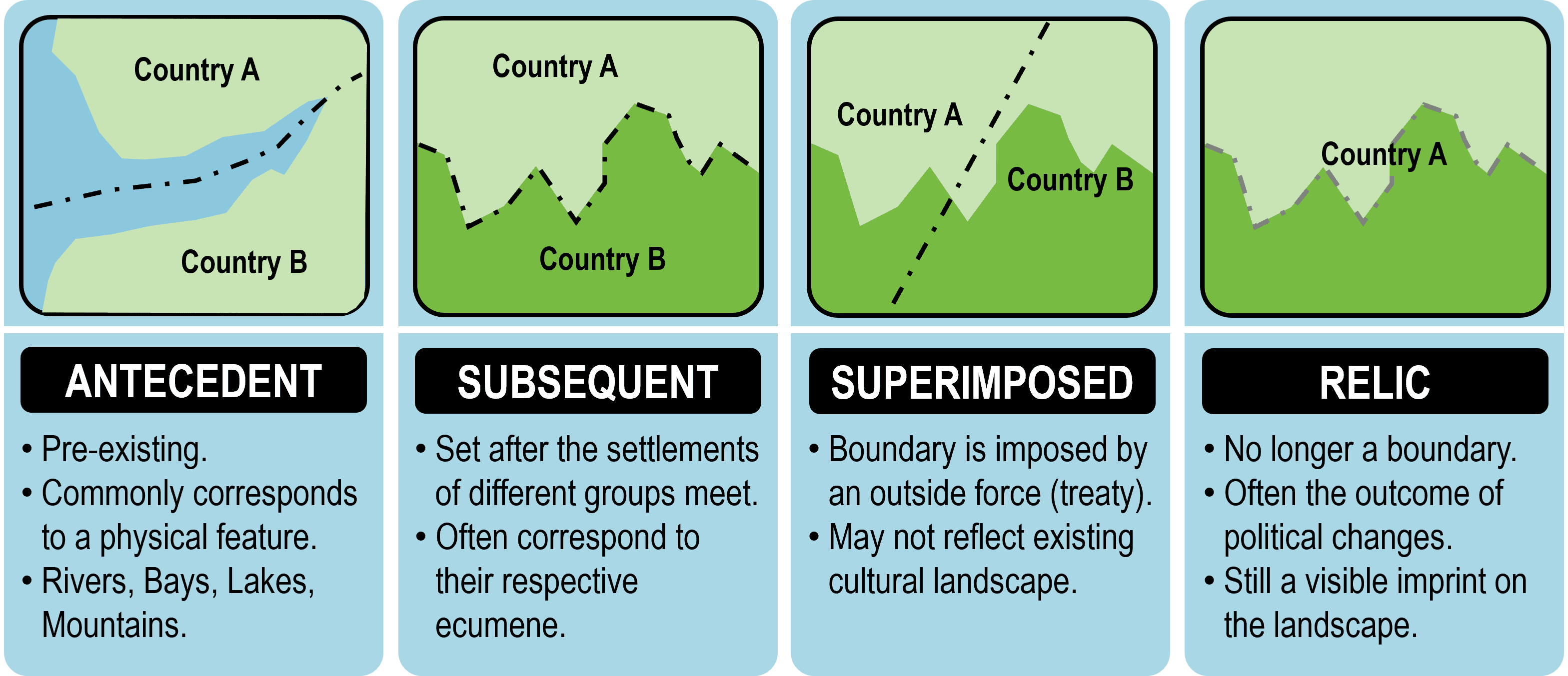
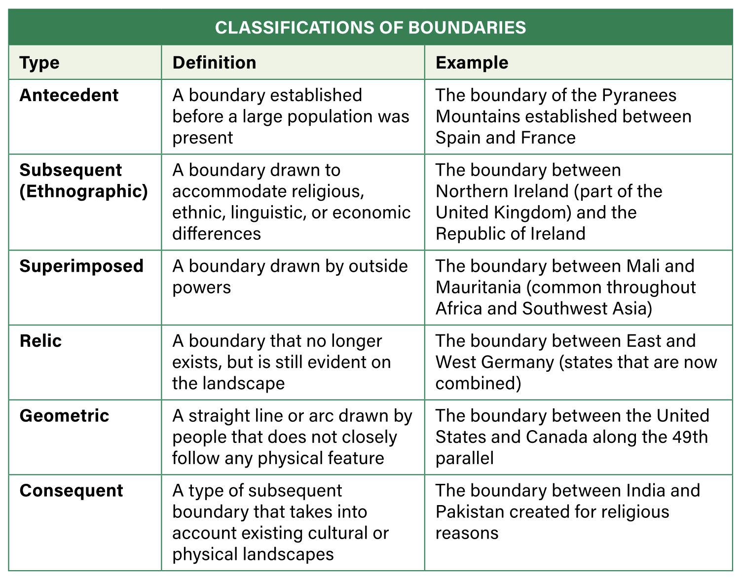
antecedent
subsequent
consequent
superimposed
geometric
relic
natural
frontier
Ocean/Sea Boundaries
L:aw of the Sea
territorial waters
contiguous zone
exclusive economic zone (EEZ)
international waters
Look at just about any map, and you’re probably looking at a reference map—the kind that shows physical features like mountains and rivers, along with human-made ones like cities, roads, and country borders. No matter what scale you’re looking at (a neighborhood, a region, or a whole continent), boundaries are everywhere. Sometimes they’re obvious—like fences, walls, or rivers. Other times, they’re completely invisible. But either way, these boundaries play an important role in how we organize space, power, and identity.
Two Big Types: Physical vs. Cultural Boundaries
All political borders fall into two main categories: physical boundaries and cultural boundaries.
- Physical boundaries use natural features to separate areas. Think oceans, deserts, and mountain ranges. These features often make it hard for people to move across them, so they naturally become dividing lines. For example, the Missouri River acts as the border between Iowa and Nebraska, and the Himalayas create a dramatic boundary between India and China.
- Cultural boundaries, on the other hand, separate people based on things like language, religion, or ethnicity. But these aren’t always clean lines. For example, in China, there used to be a general division between regions where people mostly ate wheat-based foods (like noodles) in the north and rice-based dishes in the south. But there was never a sharp line—just a gradual shift in food traditions as you moved through the country.
And sometimes, boundaries are both physical and cultural. A mountain range could split groups of people and their languages or religions. In other words, borders can tell us a lot about how people live, interact, and organize themselves.
Beyond Just What They Are: How Boundaries Happen
Knowing whether a boundary is physical or cultural helps explain what the border is. But geographers also want to know how and why that border ended up there in the first place. That’s where more detailed boundary classifications come in—categories that explain how borders were created, changed, or enforced over time.
How Boundaries Form: Three Types That Shaped the Map
Not all political boundaries are created the same way. Some form naturally over time. Others are drawn with no regard for the people living there. Understanding how and when a boundary was created helps explain many of today’s political conflicts, power struggles, and tensions between countries or groups. Here are three important types of boundaries to know:
Antecedent Boundaries: The Border Was There First
An antecedent boundary is a border that existed before people really settled the area or developed a cultural identity there. These boundaries are often based on natural features like mountains, deserts, or oceans—places that made travel or communication difficult, which meant people stayed separated by default.
- Think about the straight-line state borders in the western U.S. A lot of them were drawn before many people lived there, and they stayed in place as the population grew.
- The Andes Mountains, running along the edge of South America, formed a natural division that still separates Chile from Bolivia and Argentina today.
- Even oceans can serve as antecedent boundaries. The Atlantic and Pacific Oceans helped separate early colonial powers and are still major geographic divides today.
But not all natural features work well as boundaries. A river, for example, might seem like a good dividing line because it creates space between groups. But rivers also make travel and trade easier, which can increase connections instead of separating people. In some cases, this causes conflict—like with the Jordan River, where Israel, Lebanon, Jordan, and Palestine have long disputed access to freshwater.
Bottom line: Antecedent boundaries come before people fill in the land—but just because they’re natural doesn’t mean they’re always effective.
Subsequent Boundaries: Borders That Change With the People
A subsequent boundary forms after people have settled in an area and often reflects the cultural landscape as it develops. These boundaries are shaped by differences in things like language, religion, or ethnicity—and they can change over time, especially after conflict or negotiation.
- A famous example is the border between Northern Ireland and the Republic of Ireland. For centuries, the British encouraged Protestant settlers from England and Scotland to move into the mostly Catholic island of Ireland. Over time, tensions grew between the two groups.
- In 1921, after years of conflict, Northern Ireland chose to remain part of the United Kingdom, while the rest of Ireland became independent. A commission drew the boundary to reflect religious and political differences.
Bottom line: Subsequent boundaries are created during or after human settlement, often based on cultural divisions—and they can evolve over time.
Superimposed Boundaries: Drawn by Outsiders
A superimposed boundary is one that’s forced onto an area by a powerful outside group, often with no regard for the people already living there. These borders are usually drawn without considering natural features or existing cultural divisions—and they can leave behind serious problems.
- The most famous example is Africa during colonization. In the Berlin Conference (1884–85), European powers met to divide the African continent among themselves—even though most of the interior was still under local rule.
- They drew borders on maps without knowing much about the land or the hundreds of indigenous cultures that lived there. The result? Around 50 countries were created out of 1,000+ ethnic and cultural groups, many of whom were now forced into the same country—or split across borders.
These colonial-era borders still exist today. And they left behind issues like:
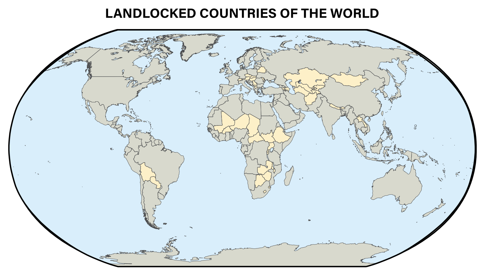
- Landlocked countries (like Botswana and Rwanda) that don’t have direct access to the ocean, making it harder and more expensive to trade.
- A legacy of political instability, conflict, and inequality that still affects many African nations.
Bottom line: Superimposed boundaries are drawn by outsiders and often ignore the realities on the ground—leading to long-lasting challenges.
One lasting impact of the “Scramble for Africa” is that it split up the continent into about 50 oddly shaped countries, often cutting through more than 1,000 different indigenous cultures. These borders weren’t drawn to reflect the people living there—they were created by European powers with little knowledge or concern for local communities.
Out of today’s 54 African countries, 17 are landlocked, meaning they have no direct access to the ocean. That’s a big deal. Countries that can’t reach a port must rely on their neighbors to trade goods in or out. That makes everything more expensive and puts these countries at a constant geographic and political disadvantage.
Governments in landlocked nations often have less power in negotiations, especially when they need to work with coastal countries to access trade routes. While some landlocked nations—like Botswana and Rwanda—have found success through smart economic policies, many others remain poor and underdeveloped, struggling to overcome the challenges that come with their location.
Relic Boundaries: Borders That Leave a Mark
A relic boundary is a political border that no longer functions but still leaves a visible mark on the landscape. Even though it’s no longer used to separate governments or control territory, the physical or cultural evidence of the boundary remains.
One of the most famous examples is the Berlin Wall. Built in 1961 to separate East and West Berlin during the Cold War, it was torn down in 1989 as Germany reunified. Today, parts of the wall are still standing—not to divide people, but as a historic reminder and tourist attraction.
Another example is the Great Wall of China. It once served as a military boundary to keep out invasions, but now it has no political role. Still, it’s a huge and lasting feature on the landscape—a powerful symbol of a past political era.
Relic boundaries remind us how much political geography can change, even while the land still carries the memory.
Geometric Boundaries: Borders Drawn Without Nature or Culture in Mind
A geometric boundary is a border drawn by people, often as a straight line, that doesn’t follow any natural or cultural feature. These are usually created by governments or outside powers and are based on math, not geography. They often follow lines of latitude or longitude—imaginary lines we use to measure Earth, not something visible on the ground.
One example is the border between the United States and Canada, which runs in a straight line along the 49th parallel (a line of latitude) for hundreds of miles. Another is the line that separates North and South Korea, drawn along the 38th parallel after World War II—not because of any mountain or river, but because it was a convenient halfway point between the areas controlled by the U.S. and the Soviet Union. Even some U.S. states—like Colorado and Wyoming—have borders that are just straight lines with no connection to the land or people.
Geometric boundaries often ignore what’s happening on the ground—who lives where, how people interact, or what natural features exist—because they’re drawn from far away, with a ruler and a map.
Consequent Boundaries: Borders That Follow What’s Already There
Unlike geometric boundaries, consequent boundaries try to match the real world. They’re drawn after people have settled in an area and are shaped by what already exists—either in the natural environment or in human culture.
A cultural consequent boundary is drawn to reflect differences between groups of people, like language, religion, or ethnicity. For example, in 1947, the region of South Asia was under British control and included what is now India, Pakistan, and Bangladesh. As the British prepared to leave, tensions were rising between religious groups. To reduce conflict, the land was divided: the new country of India had a Hindu majority, while Pakistan was created for the Muslim population. This division was an attempt to match the political boundary with the cultural reality on the ground—even though it led to major problems and mass migration.
A physical consequent boundary is based on natural features that already separate people—like mountains, rivers, or deserts. A good example is the Pyrenees Mountains, which form a rugged barrier between France and Spain. That mountain range also surrounds a tiny country called Andorra, which sits high up in the mountains between the two. Because mountains make travel and communication difficult, they naturally divide people, which is why they often become boundaries.
Consequent boundaries are shaped by real-world conditions, making them feel more natural and understandable—but they can still lead to problems, especially if the cultural or physical landscape changes over time.
Protection of Boundaries: How Borders Are Controlled or Left Open
Some borders are easy to cross. Others are designed to keep people out—or in. While boundaries can be classified by how they were created (like geometric, superimposed, or consequent), they can also be described by how protected or open they are today. The level of protection often reflects the relationship between neighboring countries, as well as political goals like security, trade, or immigration control.
Open Boundaries: When Crossing Is Easy
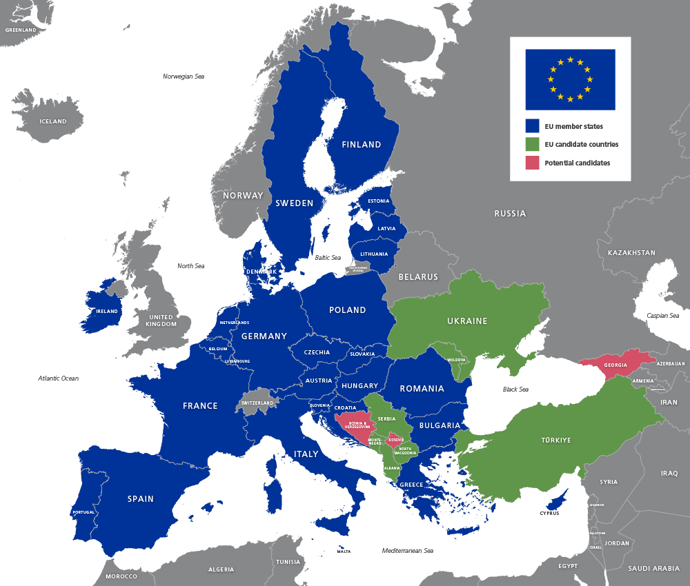
An open boundary is a border where people can move across freely, with little or no interference from the government. These types of borders are rare and usually only exist between friendly countries that trust each other and have a long history of cooperation.
The best example is the European Union (EU). Many EU countries have open borders with one another, meaning people can live, work, and travel across countries without showing a passport. For instance, someone could drive from France to Germany or Italy to Austria without stopping at a checkpoint. These open boundaries help build trade, travel, and a shared European identity.
Militarized Boundaries: When Crossing Is Dangerous or Blocked
A militarized boundary is the opposite. These borders are closely guarded, sometimes with fences, walls, soldiers, or surveillance. The goal is to control or prevent movement, especially in areas with conflict, tension, or fear of invasion.
Some militarized borders are simply patrolled by guards, but others are fortified with physical barriers. For example, in 1989, when the Berlin Wall came down, there were only 15 major border walls in the world. By 2020, that number had grown to more than 70, showing how many governments are choosing to use barriers to limit movement.

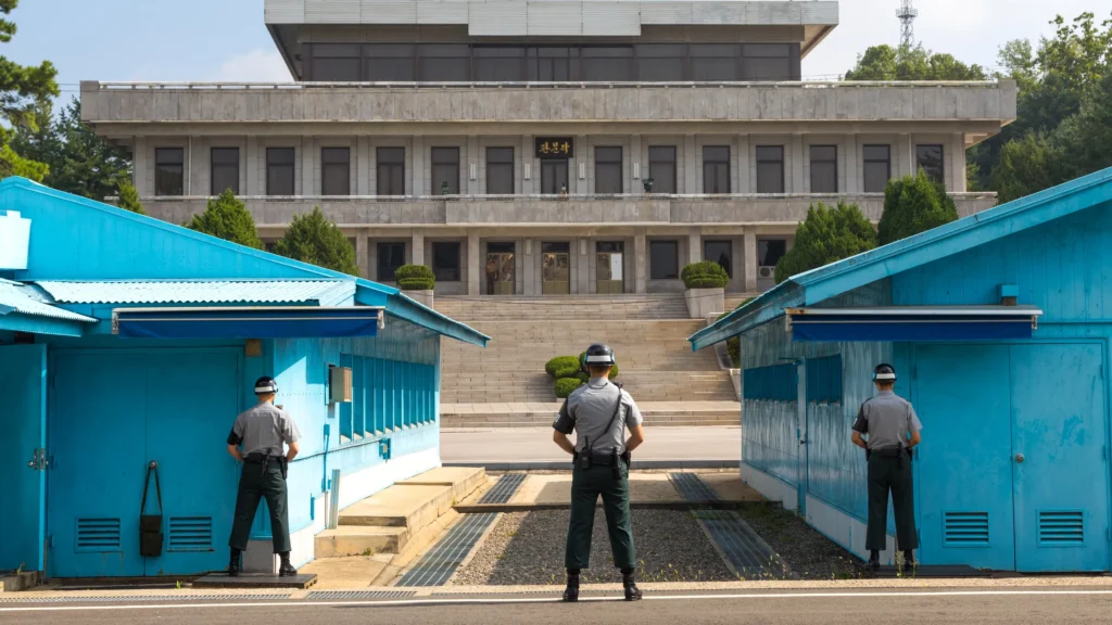
One of the most intense examples is the Korean DMZ (Demilitarized Zone). It’s a heavily guarded strip of land that separates North Korea and South Korea. It stretches 160 miles across the peninsula and is about 2.5 miles wide. Even though it’s called “demilitarized,” both sides have military forces positioned nearby. After the Korean War ended in a ceasefire in 1953, the DMZ was created as a buffer zone to reduce the risk of future fighting.
Today, the DMZ almost completely blocks trade, travel, and communication between the two countries. The United States also has a major military presence along the South Korean side—over 28,000 troops were stationed there in 2020—as a way to discourage aggression from the North.
The Function of Political Boundaries: More Than Just Lines on a Map
When people think of a boundary, they usually picture a line on a map or a fence on the ground. But in geography, a boundary is much more than that. It’s actually a vertical plane—an invisible wall that goes underground into the soil, stretches up into the air, and, in some cases, even extends into space. That means political boundaries don’t just mark land—they can also define control over underground resources, airspace, and access to satellites.
Political boundaries are used to divide the world into manageable units. They separate countries, states, provinces, counties, cities, and towns. Boundaries are also used in bodies of water—like seas or lakes—especially when multiple countries claim the same water resources. These dividing lines help governments know who is in charge of what and where their authority begins and ends.
International and Internal Boundaries: Dividing the World and the Neighborhood
All boundaries—whether they separate whole countries or small towns—are supposed to bring clarity. They tell governments and people where one political area stops and another starts. This helps with laws, taxes, elections, services, and identity.
- International boundaries divide entire countries. For example, the border between Mexico and the United States is an international boundary.
- Internal boundaries divide space within a country, like the border between California and Nevada, or between two school districts or voting regions.
In theory, boundaries are meant to bring order. But in reality, they often lead to conflict—especially when people disagree about where the boundary should be, or when a border is poorly drawn, outdated, or disputed. Throughout history, arguments over borders have caused tension, battles, and full-scale wars.
Understanding how boundaries are created and why they matter is essential to making sense of many of the world’s biggest political issues—past and present.
Formation of Boundaries
Boundaries represent changes in the use of space from one political entity to another. Crossing a boundary implies that some rules, expectations, or behaviors change. When moving across a formal political boundary, these rules are called laws. Boundaries can be identified in various ways:
- A defined boundary is established by a legal document, such as a treaty, that divides one entity from another (invisible line). The entity could range from a country-in which points of latitude and longitude are specified- to a single plot of real estate- in which points in the landscape are described.
- A delimited boundary is drawn on a map by a cartographer to show the limits of a space.
- A demarcated boundary is one identified by physical objects placed on the landscape. The demarcation may be as simple as a sign or as complex as a set of fences and walls.
International Boundary Disputes: When Borders Become Battlegrounds
As more countries have formed over the past 100 years, the number of boundary disputes has grown too. Borders are supposed to help organize space, but when countries disagree about where those borders are—or how they should work—conflict often follows. These disputes can happen on land or at sea, and they may involve maps, military action, or long negotiations.
Geographers group these disputes into four main types:
1. Definitional Disputes: Arguing Over What the Border Means
These happen when countries disagree about the language or interpretation of a boundary agreement or treaty. The problem isn’t where the border is drawn, but what the words in the treaty actually mean.
Example: Two countries might both claim an area because the original agreement used vague terms like “the ridge” or “the valley,” without clearly identifying which one.
2. Locational (Territorial) Disputes: Arguing Over Where the Border Is
These disputes occur when countries disagree about the exact location of a border. Even if a treaty exists, the physical landscape might have changed, or the maps might have been unclear.
Example: A river that serves as a boundary might shift its course over time, leading to confusion about which side owns the new land.
3. Operational (Functional) Disputes: Arguing Over How the Border Should Work
In this case, countries agree on where the border is, but disagree on how it should be managed. This can involve disagreements over border security, immigration policies, or how goods move across.
Example: One country may want to enforce strict border checks, while the neighboring country wants to keep the border open for trade or family visits.
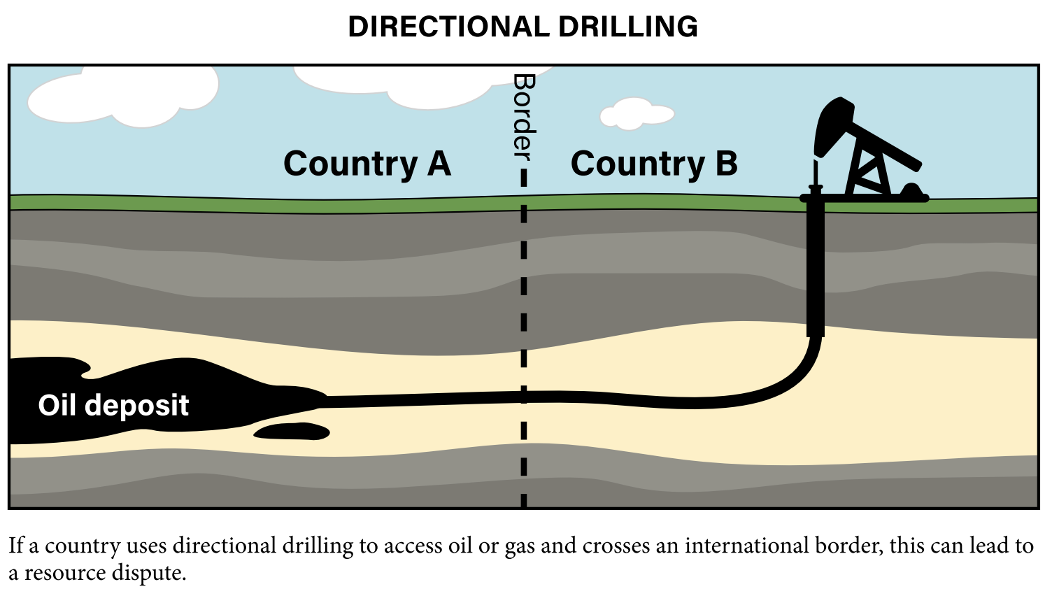
4. Allocational (Resource) Disputes: Arguing Over What’s Under or Around the Border
These disputes focus on natural resources that lie near or on the border—like oil fields, gas reserves, or fishing zones. Countries may fight over who has the right to use or control the resource.
Example: If a valuable oil field sits along a poorly defined border in the ocean, two countries may claim the same spot.
These disputes show that boundaries aren’t just lines on a map—they’re deeply connected to power, resources, identity, and control. When borders are unclear, unstable, or unfair, they often become flashpoints for international tension.
Unique Boundaries: Exclaves and Enclaves That Break the Rules
Most countries are made up of one continuous piece of land, but not always. Sometimes, parts of a country end up separated from the rest—either by natural borders, political deals, or historical events. These areas are called exclaves and enclaves, and they show how complicated political geography can get.
Exclaves: Separated But Still Connected
An exclave is a piece of a country that is physically separated from the main part of that country by another country (or countries) in between. The exclave still belongs to the same government, but it’s not connected by land to the rest of the country.
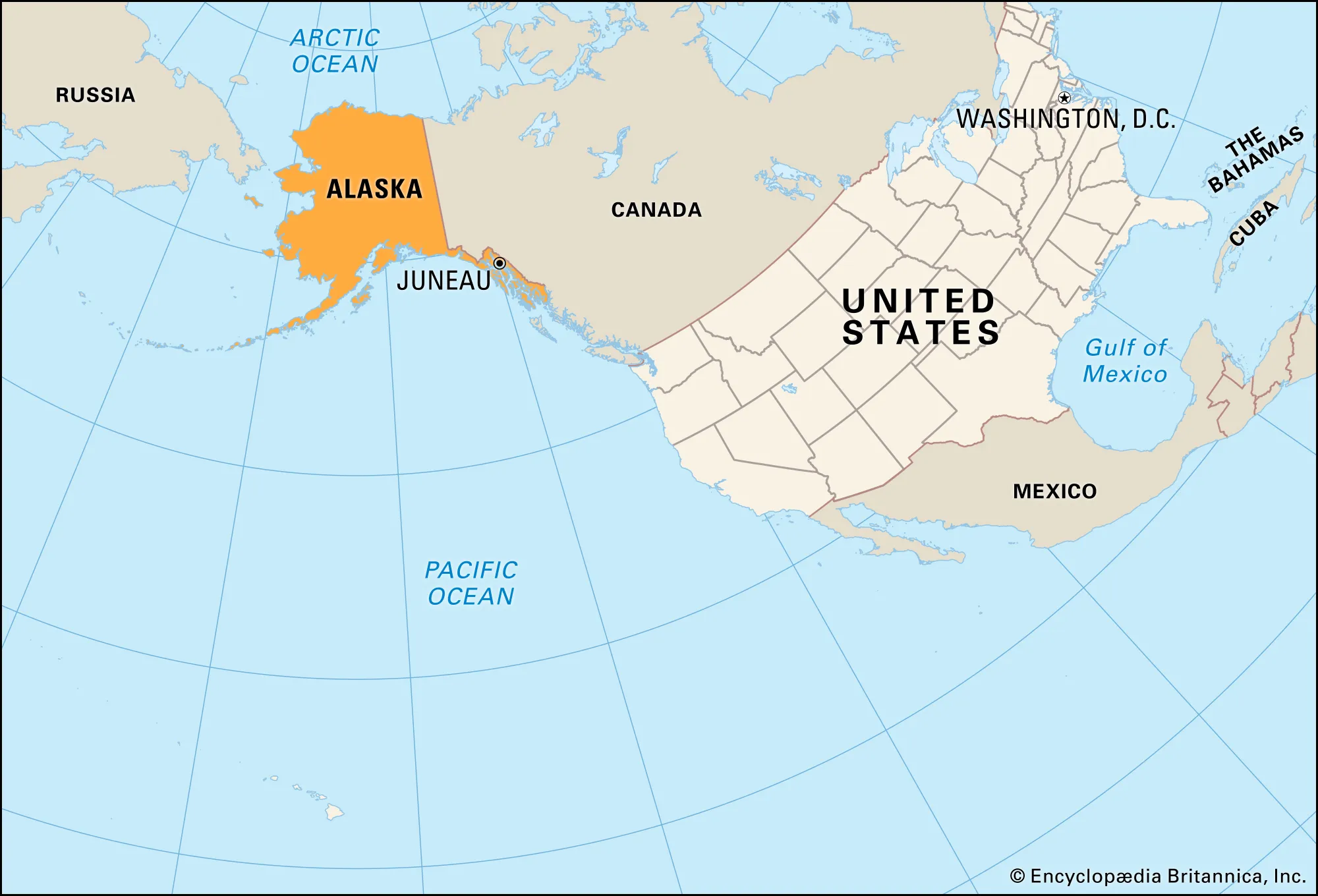
- A well-known example is Alaska. Even though it’s part of the United States, you can’t drive there from the other 48 states without going through Canada first. It’s separated, but still part of the U.S.
- Another example is Kaliningrad, a small region that belongs to Russia but is located between Poland and Lithuania, with no land connection to the rest of Russia.
Exclaves can make transportation, communication, and even national defense more difficult. They also raise questions about identity, trade, and political control.
Enclaves: Surrounded on All Sides
An enclave is the opposite. It’s a territory that is completely surrounded by another country or state. Enclaves are isolated from everything else, often due to old borders or political agreements.
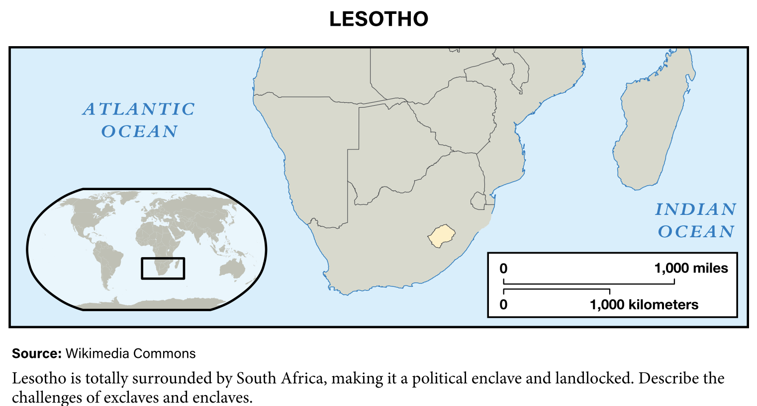
- The country of Lesotho is a great example—it’s a completely independent country, but it’s entirely surrounded by South Africa.
- In a different context, the Vatican City is an enclave inside the city of Rome, fully surrounded by Italy, though it’s a sovereign state with its own government.
Sometimes a place can be both an enclave and an exclave, depending on the perspective. These unique situations show how history, politics, and geography combine to create complex and unusual borders around the world.
Indian reservations within the United States may be considered enclaves as they possess tribal sovereignty and are recognized as independent nations.
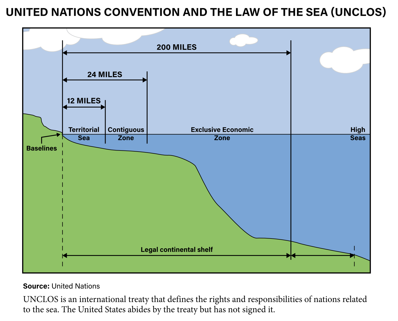
The Law of the Sea: Drawing Borders on Water
Just like countries have borders on land, they also need rules for where their territory ends in the ocean. But unlike land borders, ocean boundaries can be more complicated. How far out into the sea should a country’s control go? Who owns the resources under the water? And what happens when two countries are close together?
These questions led to international disagreements for years. To bring order to ocean politics, more than 150 countries signed an agreement called the United Nations Convention on the Law of the Sea (UNCLOS) between 1973 and 1982. It created a system to divide the ocean into four clear zones:
1. Territorial Sea: Full Control Close to Shore
This zone stretches up to 12 nautical miles from a country’s coastline (about 13.8 regular miles). Here, the country has full sovereignty, just like on land. Other countries’ ships can pass through—but military or government ships may be challenged or denied access if they’re seen as a threat.
2. Contiguous Zone: Limited Control a Bit Further Out
From 12 to 24 nautical miles offshore, countries don’t have full control, but they can still enforce certain laws—especially those related to immigration, customs, and pollution. This gives them some power to protect their borders from illegal activities happening just outside their main territory.
3. Exclusive Economic Zone (EEZ): Rights to Resources
This is the big one. A country’s EEZ stretches up to 200 nautical miles (about 230 regular miles) from its coast. In this zone, the country doesn’t own the water, but it has the exclusive right to use the resources in it—like fishing, drilling for oil, or mining underwater minerals.
4. High Seas: Open to Everyone
Everything beyond a country’s EEZ is known as the high seas. No one owns this space. All countries have equal rights to sail, fish, research, or explore here. It’s basically international water, open to all but protected by global agreements to avoid overuse or abuse.
These zones help prevent conflict and manage ocean resources fairly—but disputes still happen, especially when EEZs overlap or when valuable resources like oil or fish are involved. The Law of the Sea shows how even water needs clear boundaries.
When Coasts Are Close: Splitting the Sea Fairly
Sometimes, two countries are so close to each other that their territorial seas or EEZs would overlap. In these cases, international law uses a simple rule: split the distance in half.
If two coastal states are less than 24 nautical miles apart, they can’t each claim the full 12 nautical miles of territorial sea without overlapping. So instead, the midpoint is used to draw the boundary. Each country gets half the distance from shore to shore.
For example, if two countries are separated by just 20 nautical miles of water, each one would be allowed 10 nautical miles of territorial sea. This method helps avoid conflict and keeps maritime boundaries fair when geography brings nations close together.
The Value of Islands: Small Land, Big Ocean
Islands may look small on a map, but they can give countries huge amounts of power over the ocean. Thanks to the 200-nautical-mile Exclusive Economic Zone (EEZ) rule, even a tiny island can extend a country’s ocean rights by hundreds of miles in every direction.
For example, in Alaska, some of the farthest U.S. islands stretch deep into the Bering Sea. Each one creates its own 200-mile EEZ, giving the United States control over a massive area of ocean. In fact, the U.S. has the largest EEZ in the world—around 3.4 million square miles—almost as large as the total land area of the entire country.
This matters even more for Small Island Developing States (SIDS)—tiny island countries scattered across the world’s oceans. While their land areas may be small, their EEZs are enormous. SIDS control nearly 30% of the world’s oceans, and their ocean zones are often hundreds or even thousands of times larger than their land.
Take Tuvalu, a small country in the South Pacific. Its land area is tiny, but its EEZ is 27,000 times larger than its land. That ocean territory includes valuable fish stocks, underwater minerals, and potential energy sources like natural gas. It also offers opportunities for tourism and sustainable ocean industries.
This growing focus on using the ocean for economic growth, especially among SIDS, is called the blue economy—a way for these countries to turn their ocean access into long-term prosperity.
Arctic Opportunities: A Melting Ocean Opens New Doors
The Arctic Ocean is quickly becoming one of the most contested regions on Earth. As climate change causes Arctic ice to melt, countries with territory near the North Pole—like Russia, Canada, the United States, Norway, and Denmark—are looking to claim new parts of the ocean for themselves.
Why? Because as the ice disappears, it reveals valuable resources and new shipping routes. Beneath the Arctic seabed are believed to be huge deposits of oil, natural gas, and minerals. Melting ice also opens up faster sea lanes for global trade, especially during warmer months—saving ships time and fuel as they move between Europe, Asia, and North America.
These potential benefits have led to rising tensions as countries push to expand their EEZs in the Arctic, claiming territory based on underwater features like continental shelves. The Arctic is a prime example of how changing geography—in this case, driven by climate—can reshape political and economic boundaries in the 21st century.
South China Sea: Disputes Over Islands and Ocean Power
The South China Sea is one of the most heavily contested bodies of water in the world. In 2011, tensions rose over the Spratly Islands—a scattered group of small islands, coral reefs, and rocks in the middle of the sea. These islands might be tiny, but what surrounds them is hugely valuable.
The region is important for three main reasons:
- It’s a major trade route where trillions of dollars in goods pass through each year.
- It’s a rich fishing area, supporting the diets and economies of millions.
- It may contain large reserves of oil and natural gas beneath the seabed.
Countries like China, Vietnam, the Philippines, Malaysia, Brunei, and Taiwan have overlapping claims to different parts of the sea. But China has made the most aggressive moves, claiming almost the entire area as part of its territory. To back up its claims, China has built artificial islands on top of reefs and equipped them with military bases, airstrips, and ports. These artificial islands are used to try to extend China’s 200-nautical-mile Exclusive Economic Zone (EEZ) farther than it would naturally reach.
This expansion has led to rising tensions and international criticism. The South China Sea remains a hot spot for territorial disputes, military standoffs, and competing claims to valuable resources—all packed into a crowded and strategically important corner of the map.