Urban Models
Burgess Concentric Zone
Hoyt Sector Model
Multiple Nuclei Model
Galactic City Model
Latin America Urban Model
Southeast Asia Urban Model
Africa Urban Model
Zoning
central business district (CBD)
residential
industrial
commercial
Urban Patterns
beltway
squatter/informal settlements
disamenity zone
gentrification
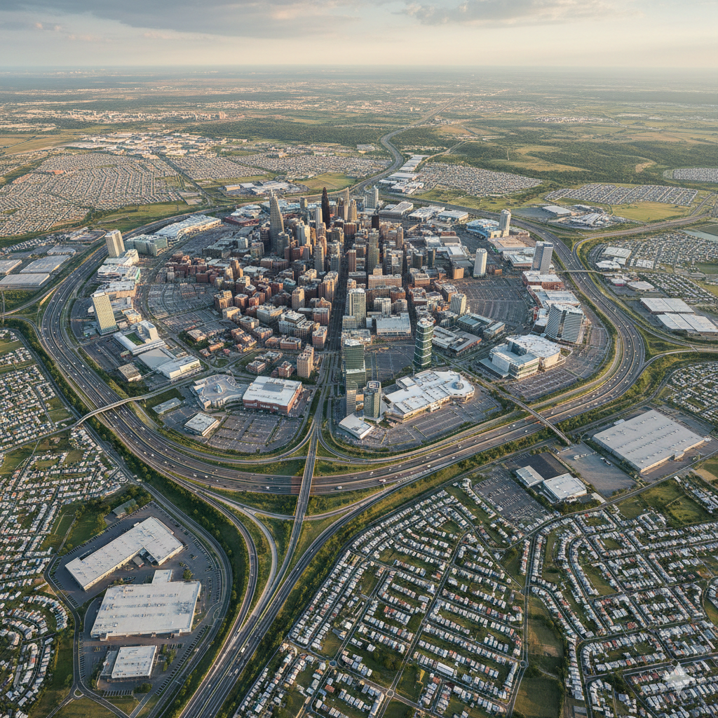
Cities are enormously complex and important centers for much of the world’s population. Since cities first emerged in human civilization, they have been centers of economic, political, and cultural power. They have been places of innovation. Cities are growing faster today than ever before in history and that trend is projected to continue.
Urban Zones
One principle underlying all urban models is functional zonation, the idea that portions of an urban area—regions, or zones, within the city—have specific and distinct purposes. The various zones fit together like a puzzle to create the entirety of the city. However, unlike a puzzle, the pieces of a city are not clearly delineated, and geographers have tried to identify and classify them with models. The resulting urban models provide geographers with a framework to describe, understand, and analyze cities. Urban areas around the world share three basic zones: the central business district, industrial/commercial, and residential.
Central Business District
A vital part of any urban model is the central business district (CBD), which is the commercial heart of a city. Often located near the physical center of a city, or the crossroads where the city was founded, the CBD is the focus of transportation and services. The bid-rent theory explains agricultural land use, just as it helps explain land use in central business districts. This theory explains that land in the center of a city will have higher value than land farther away from the city’s center. Therefore, land use will be more intense and costs will be higher closer to the CBD. This means high-order services often dominate the CBD.

Competition for valuable space in the CBD gives it certain characteristics:
- In some countries, including the United States and Canada, the CBD has skyscrapers and “underground cities” that might include facilities for parking, shopping, and rapid transit.
- In Europe, many CBDs are located in the historic heart of the city where buildings are shorter but services are still concentrated.
- Because the cost of land is high in CBDs, manufacturing activities are rarely located there.
- High costs and limited space often result in residential portions of CBDs having high-density housing, such as high-rise apartment buildings.
Industrial/Commercial Zone
The zone outside the central business district is dedicated to industry. These industrial zones may include manufacturing, warehousing, and transportation. Industrial zones are generally separated from residential areas because they are associated with air and noise pollution.
Commercial areas with lower-order services and less-intensive land use are also found outside the CBD. Law firms might locate in the CBD, but department stores usually prefer commercial shopping zones with land values.
Several factors influence the choice of locations for businesses within the commercial zone. First, the land is zoned for commercial use so they are legally allowed there. Second, some industries have a commensal relationship, which is when commercial interests benefit each other. For example, restaurants and theaters benefit by being in the same zone, as do clothing stores and shoe stores.
Residential Zone
All cities have residential zones, areas where people live. These are generally separate from the CBD and industrial zones either legally—through government zoning—or simply by the choices of inhabitants.
The different residential zones are distinct from one another. They may be segregated by density, income level, ethnic group, religion and culture, social status, or other characteristics. Which characteristic distinguishes the residential zones depends on the world region where the city is located.
Models of North American Cities
Burgess Concentric Zone Model
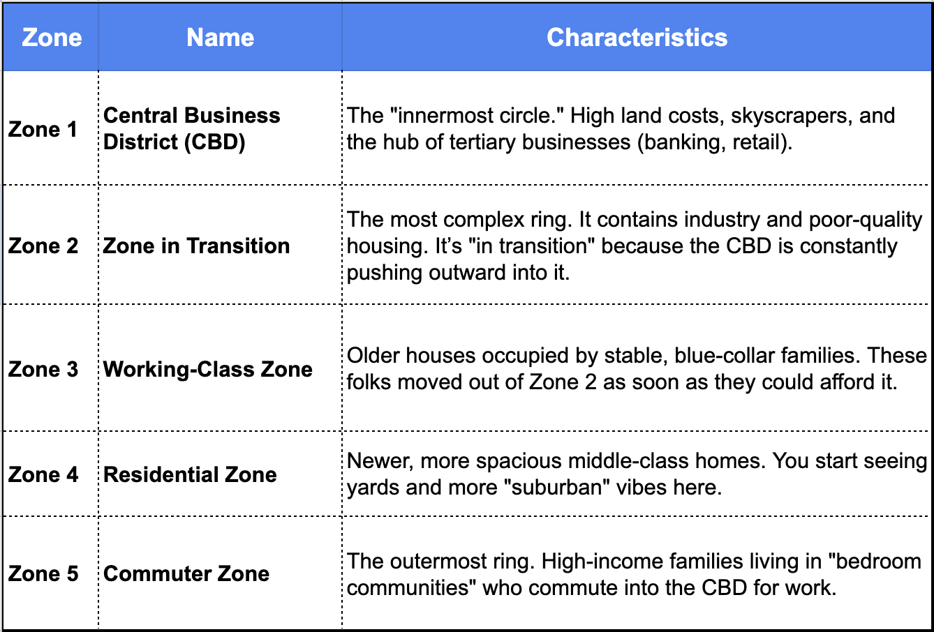
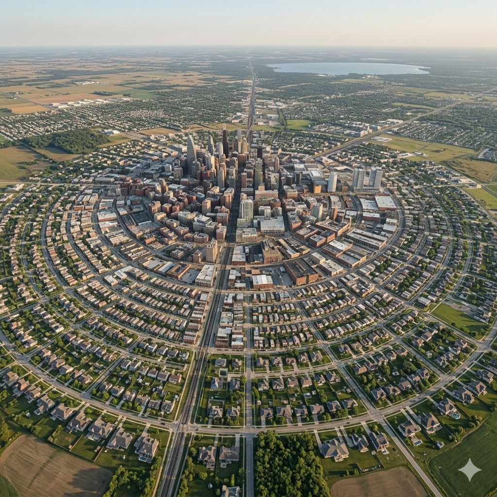
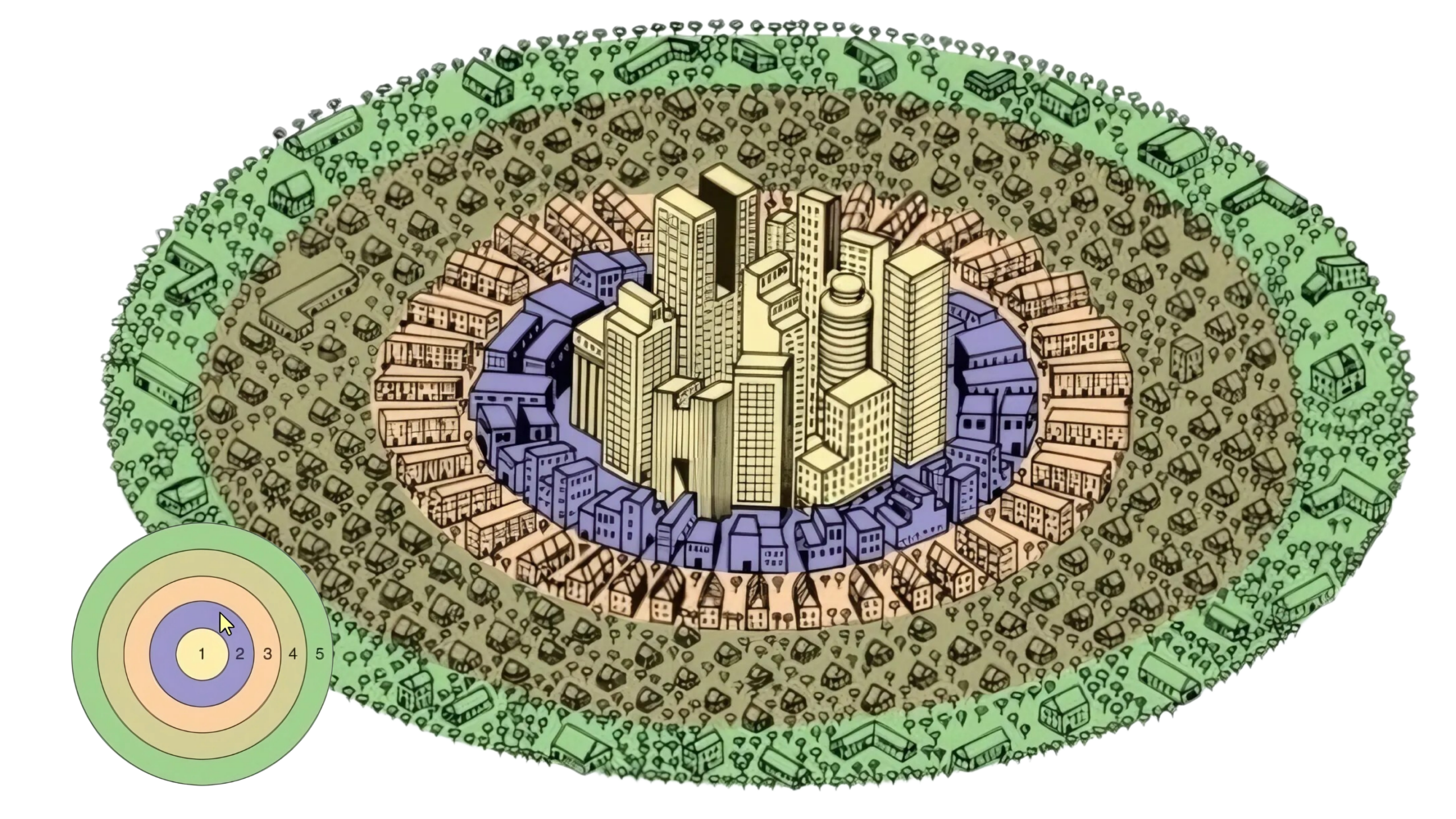
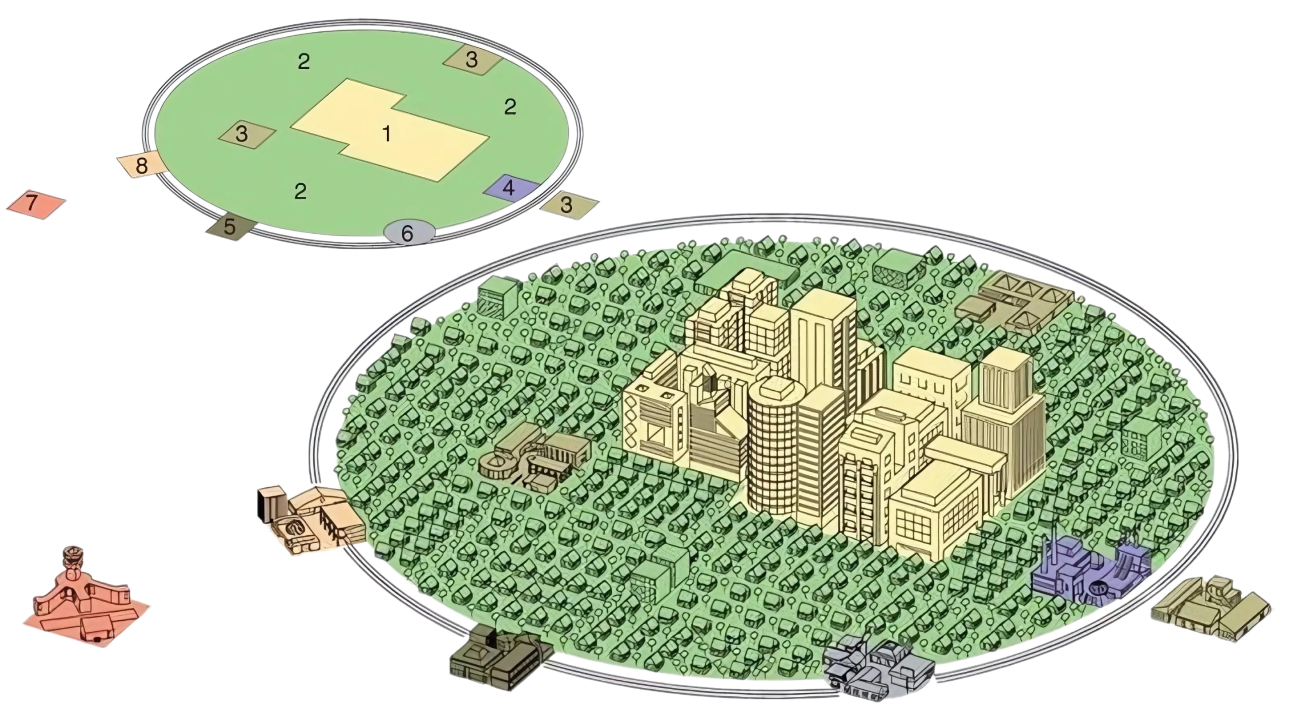
The Burgess Concentric Zone Model is the “grandfather” of urban models. Developed in 1923 by sociologist Ernest Burgess, it was the first real attempt to explain how social groups are distributed within an urban area.
The Burgess Model is an onion. It’s based on the idea that a city grows outward from a central point in a series of perfect rings.
The Five Rings of the City
Burgess based his study on Chicago during its industrial peak. He identified five distinct zones:
The Secret Sauce: Bid-Rent Theory
To truly understand Burgess, you have to understand Bid-Rent Theory.
It’s a simple economic rule: Land is most expensive near the CBD. Because the center is the most accessible point for everyone, businesses “bid” the most to be there. As you move away from the center, land becomes cheaper. This is why you see massive factories and cramped apartments near the center (Zone 2), while big houses with sprawling lawns are tucked away in the outer rings (Zone 5).
Why It’s (Mostly) Outdated
While it’s a classic for AP exams, the Burgess Model has some major “real world” flaws in the 21st century:
- Topography: It assumes the land is perfectly flat (no rivers, mountains, or lakes to get in the way).
- Transportation: It was designed before everyone had a car. It assumes people move primarily by walking or early public transit.
- Urban Renewal: In many modern cities, the “Zone in Transition” is being gentrified, meaning wealthy people are moving back into the center, which flips the model upside down.
- Industrial Shift: Heavy industry has mostly left the inner city for cheaper land further out (as seen in the Galactic Model).
Burgess noted a process called invasion and succession. As new immigrant groups arrived in the city, they typically settled in the cheapest area (Zone 2). As they gained wealth, they “invaded” Zone 3, pushing the previous residents into Zone 4. It’s a constant outward ripple of people and social classes.
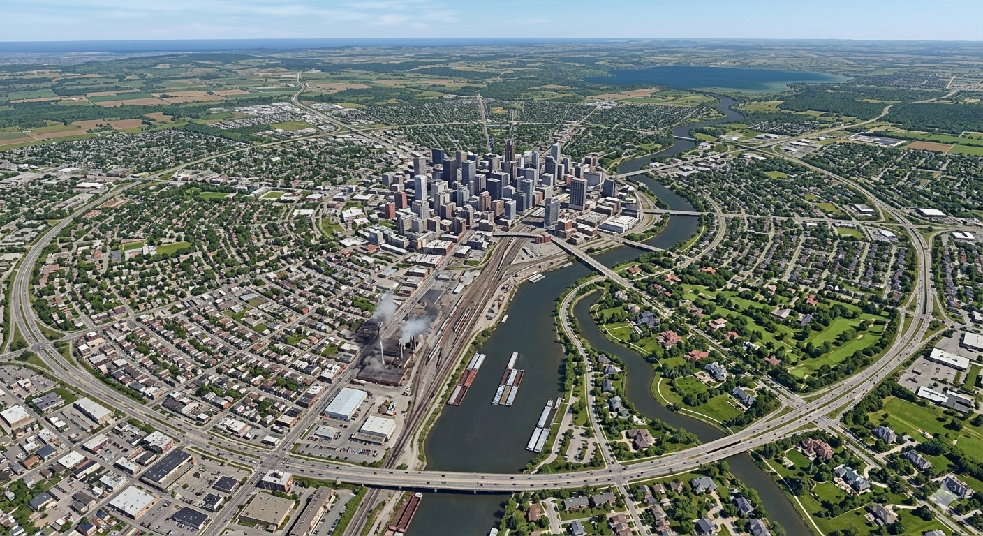
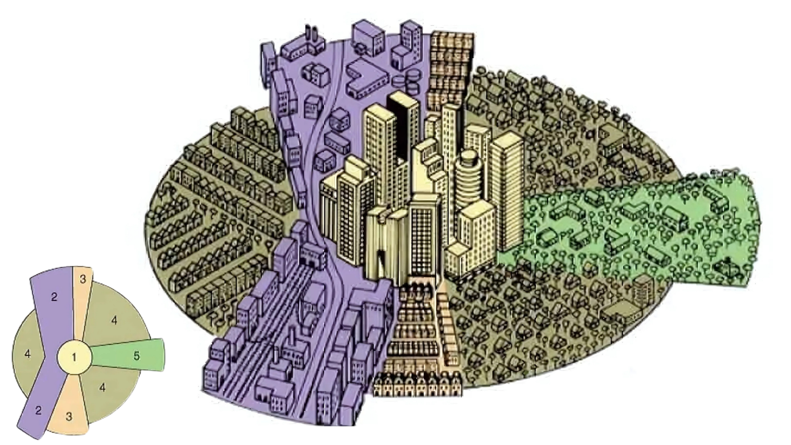
Hoyt Sector Model
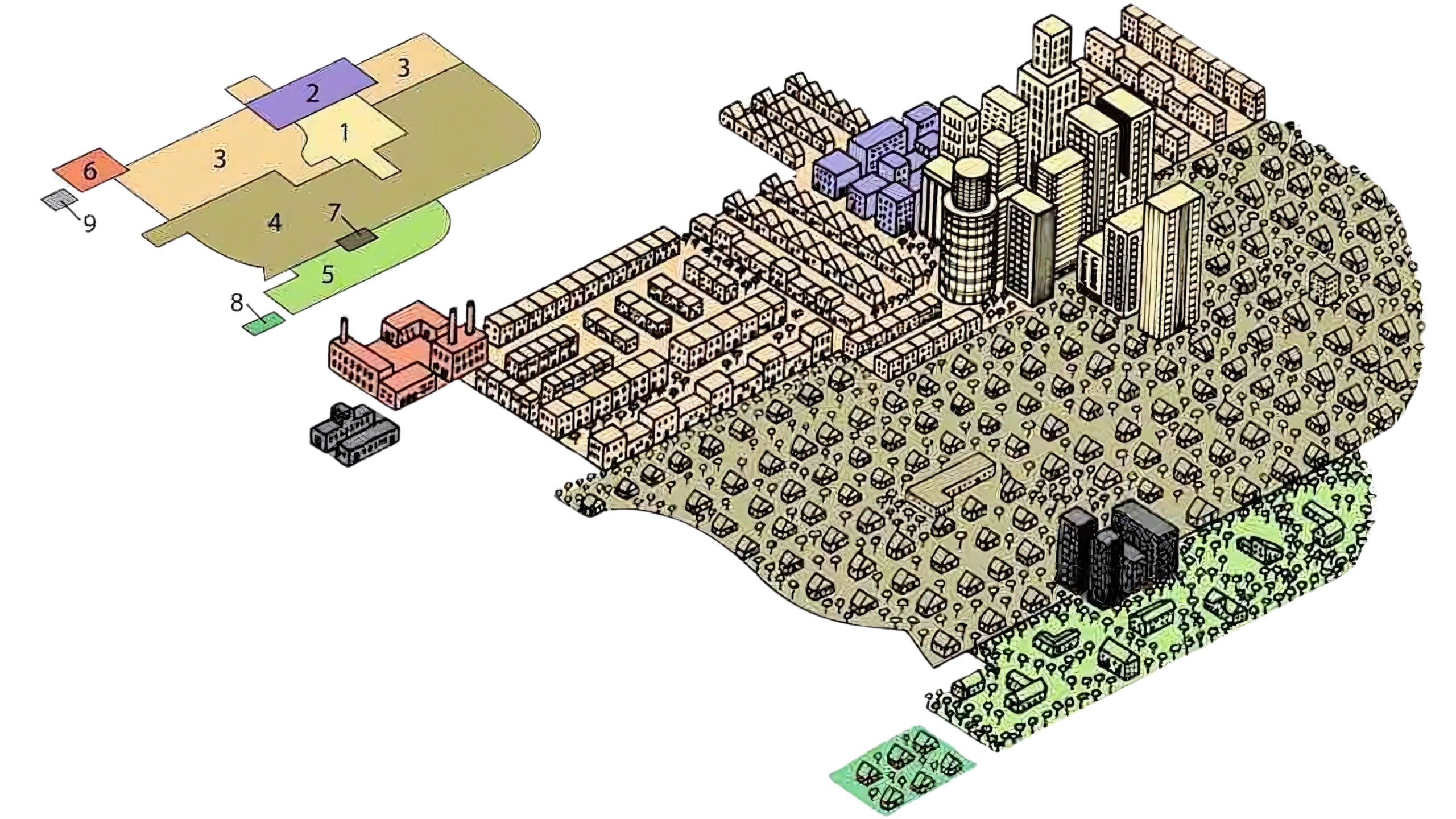
If the Burgess Model is an onion, the Hoyt Sector Model is a pizza.
Developed in 1939 by land economist Homer Hoyt, this model was a direct response to the Burgess Model. Hoyt realized that cities don’t actually grow in neat, perfect circles. Instead, they grow in wedges (sectors) that radiate out from the center along transportation corridors.
The Breakdown of the Wedges
Hoyt argued that once a specific type of land use (like high-end housing or heavy industry) starts in a certain area, it stays there and expands outward as the city grows.
- Central Business District (CBD): Still the “heart” of the city where the sectors converge.
- Transportation and Industry Sector: This wedge follows railroads, rivers, or canals. It’s where the factories are because they need easy access to move goods.
- Low-Class Residential: Located right next to the industrial sector. Why? Because it’s loud, polluted, and cheap. Workers lived here to be within walking distance (or a short transit ride) of their factory jobs.
- Middle-Class Residential: The largest sector. It acts as a “buffer” between the high-class and low-class areas.
- High-Class Residential: This is the “prestige” wedge. It develops along a specific axis—maybe a scenic ridge, a waterfront, or a high-speed boulevard—as far away from the “smelly” industrial sector as possible
The Logic: Why “Wedges”?
The Hoyt Model is defined by transportation.
In the 1930s, streetcars and trains were the primary way people moved. If a rail line ran North, the industry followed that line. If a fancy “boulevard” ran West, the wealthy followed that line.
Bid-Rent Theory still applies here, but with a twist: Hoyt argued that accessibility isn’t just about distance from the center; it’s about being near the lines of transportation that lead to the center.
Galactic Urban Model
The Galactic Urban Model (also known as the Peripheral Model) is essentially the “modern update” to traditional city structures. Developed by Chauncy Harris in the 1960s, it reflects the post-World War II shift toward suburbanization and the dominance of the automobile.
Think of it as a decentralized city that has finally “burst” its original seams.
The Core Structure
Unlike older models where everything revolves around a single downtown area, the Galactic Model shows a city that has expanded so far outward that the original center loses its absolute power.
The Major Components:
- The Central City: This is the old Central Business District (CBD). In this model, it’s often plagued by “inner-city” issues as wealthier populations and businesses have moved outward.
- The Peripheral Belt (The “Ring Road”): This is the defining feature—usually a massive highway (like a beltway) that circles the entire metropolitan area.
- Edge Cities: These are the “stars” of the Galactic Model. They are nodes of consumer and business services that pop up along the beltway, often near major intersections or airports. They function like mini-cities of their own.
- Suburban Residential Areas: Vast patches of single-family homes filling the gaps between the core and the periphery.
- Industrial Parks: Large manufacturing or distribution centers located near the beltway for easy truck access, away from city traffic.
Key Drivers of the Model
Why did cities start looking like galaxies? A few specific historical and economic shifts triggered this:
- The Rise of the Automobile: You can’t have a galactic city if everyone has to take a train to the center. High car ownership allowed people to live 20+ miles from where they work.
- Highway Expansion: The Interstate Highway System made the “beltway” possible, allowing for rapid movement around the city rather than just into it.
- The “Flight” to the Suburbs: As people moved out, businesses followed to be closer to their labor pool and customers.
- Specialized Land Use: Because land is cheaper on the edge, you see massive malls, office parks, and “big box” stores that couldn’t fit in a cramped downtown.
The name comes from the visual of the city: the Central City is the “sun,” and the Edge Cities are the “planets” orbiting around it, held together by the “gravity” of the beltway.
Multiple Nuclei Model
The Multiple Nuclei Model is a classic urban land-use model in AP Human Geography, developed in 1945 by geographers Chauncy Harris and Edward Ullman.
Unlike earlier models that assumed a city grew out of a single central point, this model argues that even though a city may have begun with a Central Business District (CBD), other smaller “nuclei” (centers) develop as the city expands.
Core Concept: Decentralization
The “big idea” here is that a city is a complex structure that lacks a single point of focus. Instead, it consists of several nodes or nuclei around which different types of activities cluster.
- The CBD is still there: It exists, but it’s no longer the only influential factor in land use.
- Specialized Cells: Certain activities (like heavy manufacturing or high-end retail) gravitate toward specific nodes based on their needs, such as proximity to highways, airports, or specific types of labor.
Why do these “Nuclei” form?
Harris and Ullman identified four main reasons why a city fragments into multiple centers:
Specific Facilities Requirements
Certain activities require specialized facilities. For example, a heavy manufacturing plant needs large plots of land and access to major railways or ports, while a retail center needs high-traffic intersections.
Agglomeration (Clustering)
Similar activities often cluster together because they benefit from each other.
- Example: Universities often attract bookstores, coffee shops, and student housing nearby.
- Example: Medical districts see hospitals, pharmacies, and private clinics all grouping together.
Incompatibility
Some land uses simply do not mix. You typically won’t see a high-end luxury residential neighborhood located directly next to a noisy, polluting industrial zone. This forces the city to develop distinct, separated nodes.
Cost and Accessibility
Not every business can afford the high rents of the CBD. Some “nuclei” form in lower-rent areas on the outskirts of the city where they can still be accessible via new highways.
The 9 Zones of the Model
In the standard AP Human Geography version of this model, there are nine distinct land-use zones:
- Central Business District (CBD): The original core.
- Wholesale/Light Manufacturing: Near transport lines.
- Low-Class Residential: Near the industrial sectors.
- Medium-Class Residential: The suburbs.
- High-Class Residential: Located far from industry, usually in a “desirable” node.
- Heavy Manufacturing: On the edge of the city near highways/rails.
- Outlying Business District: A “mini-CBD” or suburban mall area.
- Residential Suburb: Purely housing for commuters.
- Industrial Suburb: Factories located outside the city limits.
Why it matters today
The Multiple Nuclei Model was revolutionary because it reflected the reality of the automobile era. It moved away from the “walking city” or “streetcar city” and recognized that highways allowed people and businesses to move further away from the city center.
It is the precursor to the concept of Edge Cities, where suburban hubs eventually become so large they provide all the functions of a traditional downtown.


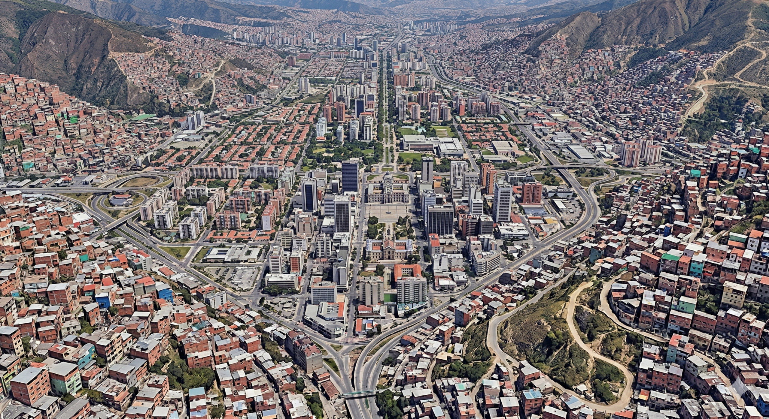
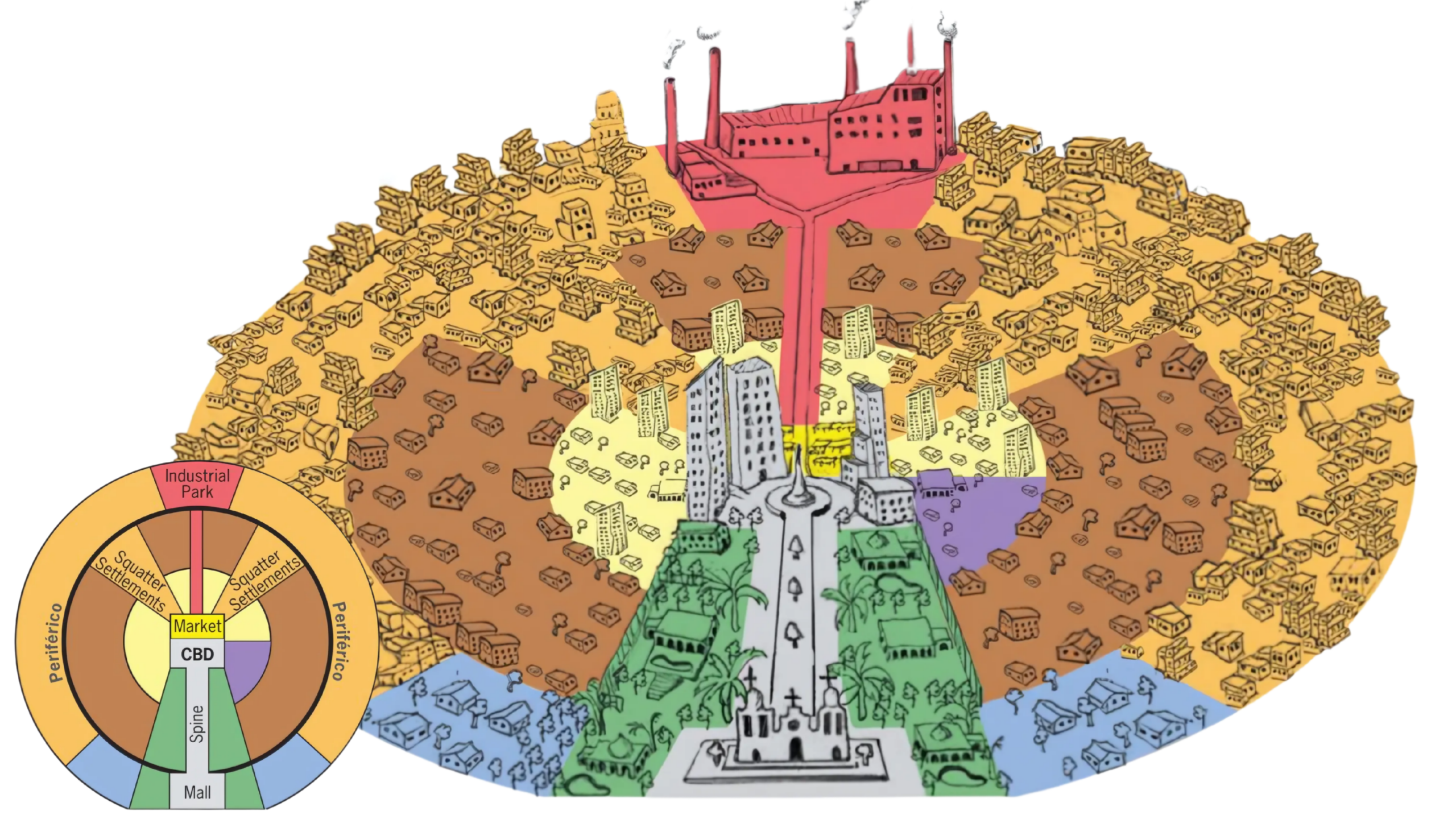
Latin American City Model
The Latin American City Model (also known as the Griffin-Ford Model) was developed in 1980 by geographers Ernest Griffin and Larry Ford. It is a staple of AP Human Geography because it illustrates how colonial history and rapid modernization blend to create a unique urban structure, very different from the North American models we’ve discussed.+1
The Core Concept: The “Spine”
The defining feature of this model is a commercial “Spine” that extends outward from the Central Business District (CBD).
- Elite Residential Sector: This spine is surrounded by the most prestigious residential area in the city. Think of it as a grand boulevard lined with high-end shops, theaters, and parks, where the wealthy live to be close to both the city center and luxury amenities.
- Infrastructure: This is often the only part of the city with reliable, high-quality public services (water, paved roads, electricity).
The 5 Major Zones
The city is organized into concentric rings and sectors that reflect a stark “Core-Periphery” relationship within the city itself:
The CBD (Central Business District)
Unlike modern U.S. cities, the CBD remains the vibrant heart of the Latin American city. It usually features a Plaza at the center, surrounded by a Catholic cathedral and government buildings—a direct legacy of Spanish colonial rule (the Laws of the Indies).
The Spine and Elite Sector
The elite live in a wedge-shaped sector pushing out from the center. As you move further away from the CBD along the spine, the land remains high-value.
The Zone of Maturity
Located immediately around the CBD, this area contains older, stable, middle-class housing. The homes are well-built, and the infrastructure is generally good.
Transition Zone
This is a “transition” zone. It contains modest housing that is constantly under construction. Homes here represent a “work in progress”—residents might add a second floor or a brick wall as they save money. Infrastructure here is spotty.
The Periphery (Disamenity Zone)
The outermost ring consists of Squatter Settlements (known as favelas in Brazil or barrios in Spanish-speaking countries).
- Location: Often on steep hillsides or floodplains—land that is undesirable for “legal” development.
- Condition: These are high-density, makeshift housing areas with little to no access to clean water, sewage, or electricity.
Unique Characteristics: Gentrification & Disamenity
There are two specific areas often highlighted in this model that are crucial for the AP exam:
- The Periférico: A peripheral highway (similar to a beltway) that often separates the “developed” city from the squatter settlements.
- Disamenity Zones: These are the poorest parts of the city that are not connected to city services and are often controlled by gangs or drug lords. They often cut through the city in “wedges” or follow industrial corridors.+1
Key Differences from North American Models
To help you compare, keep these three points in mind:
- Wealth Location: In the Latin American model, the wealthy live near the center and along the spine. In North American models (like the Galactic City), the wealthy often live in the outer suburbs.
- Infrastructure: Quality of life and services decrease as you move further from the CBD.
- The Spine: No other model features this distinct “linear” elite residential sector.
Why it looks this way: This model reflects rapid urbanization. Millions of rural people move to the city for jobs; because the city cannot build housing fast enough, these migrants are forced to build their own homes on the outskirts (the periphery).
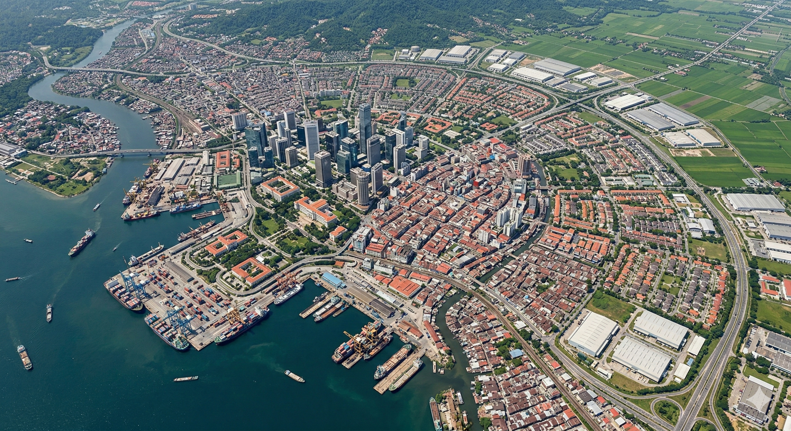
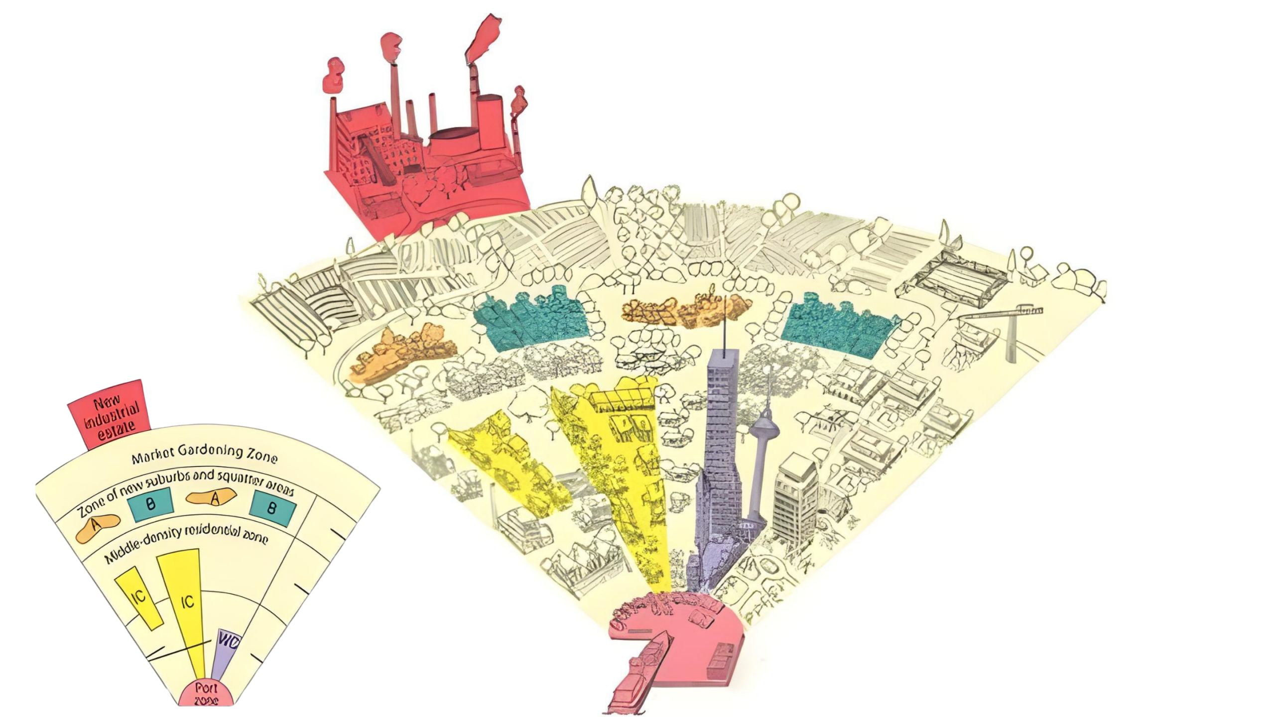
Southeast Asia Urban Model
Like the Latin American model, wealth is often tied to proximity to the core:
- High-Class Residential: Located near the government and Western commercial sectors.
- Middle-Class Residential: A growing ring of suburban-style housing.
- Squatter Settlements: Found on the periphery or in undesirable “pockets” within the city, often housing rural-to-urban migrants.
The “Market Gardening” Zone
A unique feature of this model is the presence of an Agricultural Zone on the very edge of the city. Because many Southeast Asian cities grew rapidly in areas with fertile soil, you will often see intensive farming (market gardening) happening right on the outskirts to provide fresh produce to the massive urban population.
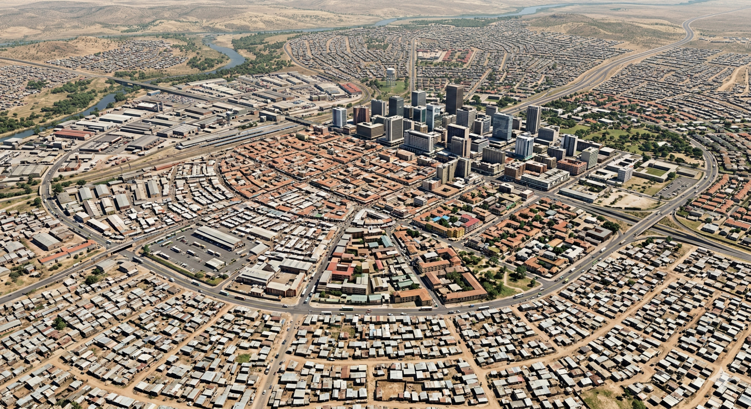
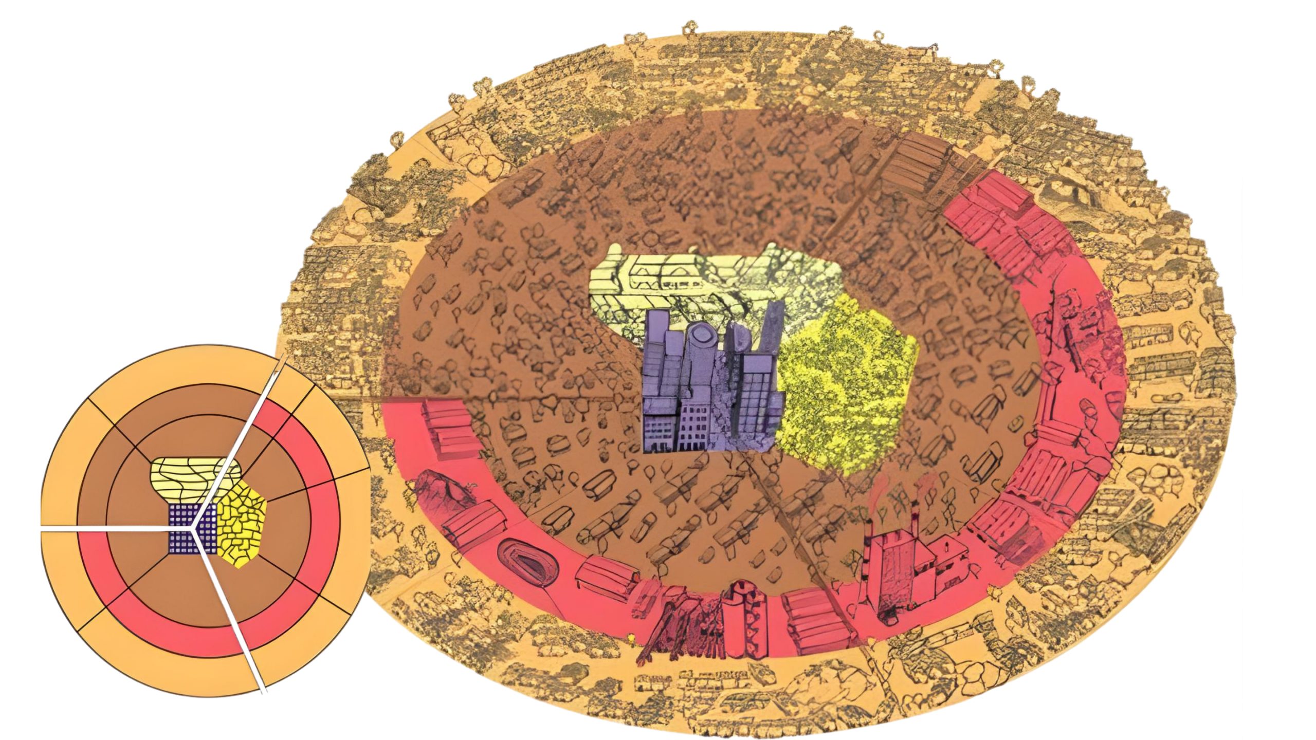
Sub-Saharan African City Model
The Sub-Saharan African City Model (often called the de Blij Model, after geographer Harm de Blij) is unique because it is the only urban model that features three distinct Central Business Districts (CBDs).
This structure is a direct reflection of Africa’s complex history, blending traditional culture, colonial occupation, and modern globalization.
The Core Concept: The Triple CBD
While North American cities have one CBD and Southeast Asian cities focus on a port, the African model is defined by three competing centers of activity:
The Colonial CBD
- Origin: Built by former European colonial powers (like the British, French, or Portuguese).
- Characteristics: It features a “gridiron” street plan, multi-story office buildings, and high-end hotels. This is the part of the city that looks most like a Western downtown.
- Function: Today, it serves as the hub for international business and government bureaucracy.
The Traditional CBD
- Origin: Existed long before or alongside the colonial era.
- Characteristics: Typically consists of open-air markets and single-story buildings. The streets are often narrower and more organic (less planned).
- Function: This is the center of local commerce and daily life for many residents.
The Market Zone (Informal CBD)
- Origin: Developed as people migrated from rural areas to the city.
- Characteristics: An ever-changing, informal cluster of stalls and “sidewalk” businesses.
- Function: This zone is critical for the informal economy, where goods are sold without government regulation or taxes. It is often located near transit hubs like bus stations.
The Concentric Rings of Growth
Beyond the three CBDs, the city is organized into rings that reflect the socioeconomic status and infrastructure availability:
- Ethnic Neighborhoods: Directly surrounding the CBDs, you often find neighborhoods clustered by ethnic groups or tribal affiliations. This reflects the strong cultural ties maintained even in a large urban setting.
- Mining and Manufacturing: Many African cities (like Johannesburg or Nairobi) grew around specific resources. You will often see a wedge or ring dedicated to industry or mining near the center.
- Satellite Townships (Informal Settlements): The outermost ring consists of rapidly growing squatter settlements. Like the Latin American model, these areas lack basic services (water, electricity) and are populated by rural-to-urban migrants looking for work.