Types of data:
qualitative
quantitative
Essential data examples:
remote information sensing
GPS (global positioning system)
landscape analysis
Making decisions:
for governments, businesses, individuals at the:
local scale
regional scale
national scale

Think about the decisions that shape your everyday life—the layout of your neighborhood, the location of schools and parks, and the routes of public transportation and roads. These choices were not random; leaders make these types of decisions using geographic data. Understanding this process is crucial because it reveals how our world functions and helps us make better decisions for the future. As we face climate change over the coming decades, significant decisions will need to be made. Whether planning neighborhood improvement projects or responding to a natural disaster, geographic data provides the insights needed to navigate today’s complex challenges and anticipate tomorrow’s needs. By learning how to interpret and use this data, we can build smarter, more resilient communities that thrive in the face of change.
Types of Geographic Data
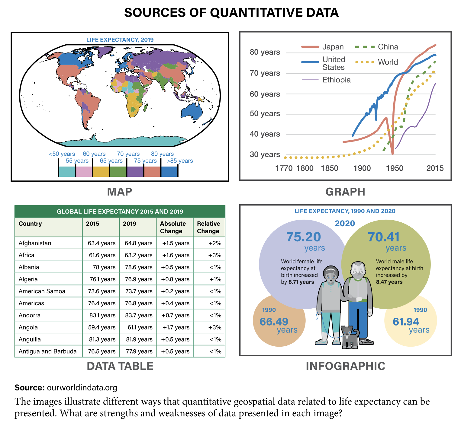
Geographic data comes in many forms, each providing unique insights into the world around us. This data can be broadly classified into two categories: qualitative and quantitative. By understanding these data types, we can better interpret current events and predict future trends.
Qualitative Data
- Field Observations: Imagine a researcher walking through a bustling market, taking notes on how people interact with their environment. These observations provide rich, detailed insights that numbers alone can’t capture.
- Landscape Analysis: Think about analyzing a city’s layout to understand how its physical features affect human activities. This helps us see the connection between our environment and our behaviors.
- Photographs: A picture is worth a thousand words, right? Photos document places and events, giving us visual context to support other data types.
- Interviews: Conversations with locals can reveal personal stories and experiences, offering perspectives that statistics might miss.
- Travel Journals: Detailed accounts of journeys that capture the essence of a place, its culture, and its people.
Quantitative Data
- Demographic Data: This includes statistics about populations, like age, gender, income, and education levels. It’s crucial for planning everything from schools to healthcare.
- Economic Data: Information on economic activities, such as employment rates and GDP. It helps us understand how wealth is generated and distributed.
- Government Documents: Official records and reports provide authoritative data on various aspects of society.
- Census Data: Comprehensive data collected from population censuses gives us a snapshot of the demographics at a particular time.
- Media Reports: News articles and media coverage can highlight trends and issues that are important to people.

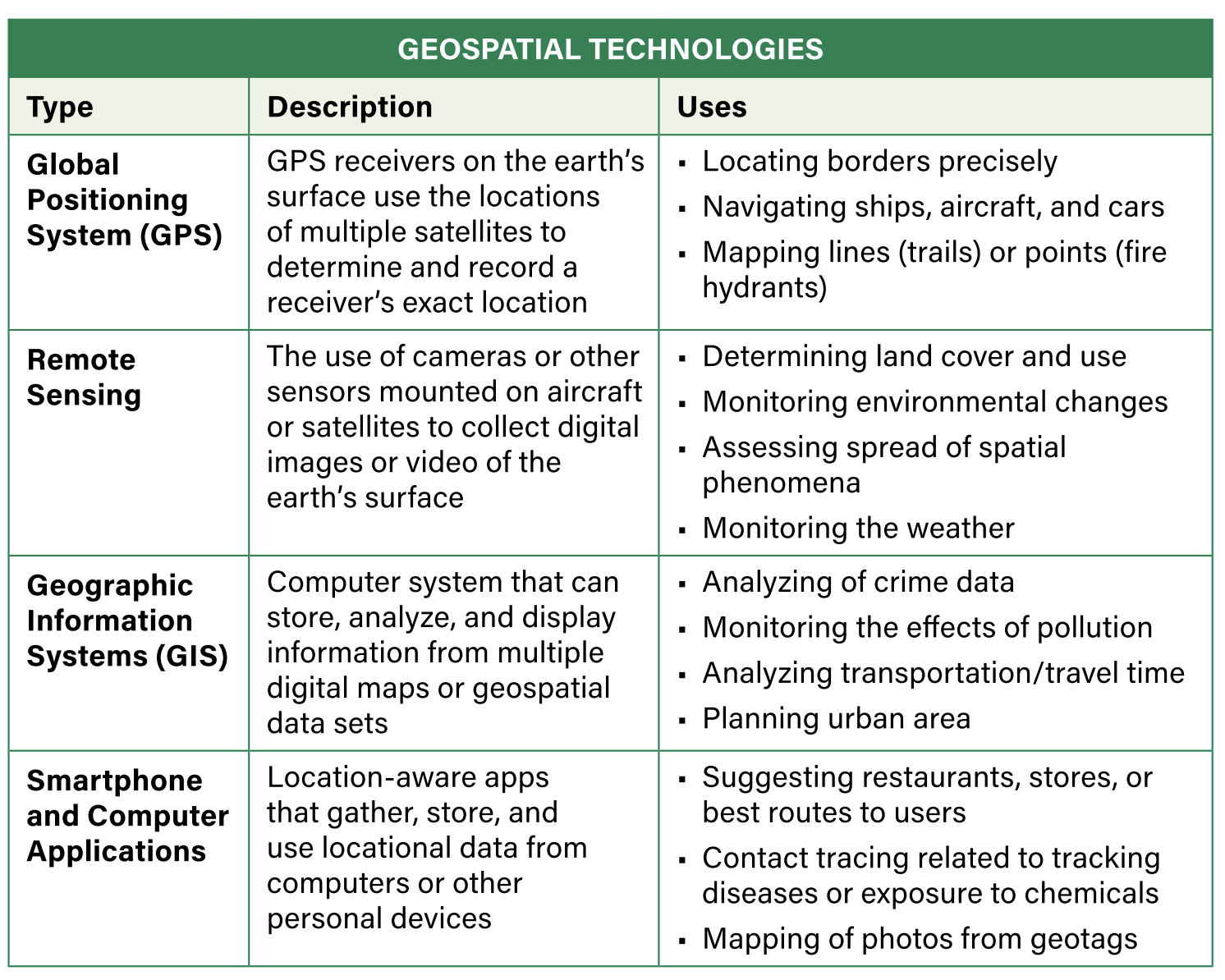
Each type of data serves a different purpose and can be collected through various methods, including Geo Informational Systems (GIS), remote sensing, and GPS. These tools help us gather, analyze, and visualize geographic data, turning raw information into actionable insights.
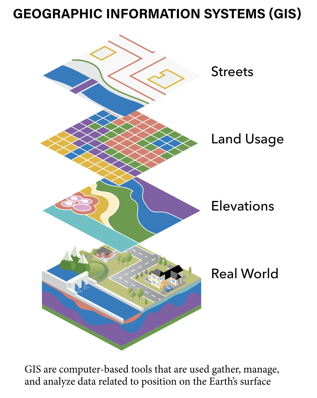
Geo Informational Systems (GIS) GIS is a powerful tool that allows us to visualize, analyze, and interpret data to understand spatial relationships and patterns. By layering different types of data on maps, GIS helps decision-makers see how various factors interact and influence each other. Imagine a map that shows not just the streets and buildings but also population density, economic activity, and environmental factors all in one place. This comprehensive view helps us make smarter decisions.

Remote Sensing
Remote sensing involves collecting data from a distance, typically using satellites or aircraft. This technology can capture images and information about the Earth’s surface, providing insights into everything from land use changes to weather patterns. Think of remote sensing as our eyes in the sky, giving us a bird’s-eye view of large areas that would be impossible to monitor from the ground.
Global Positioning System (GPS)
GPS technology uses satellites to determine precise locations on the Earth’s surface. It is widely used for navigation but also plays a crucial role in data collection, enabling researchers to accurately record the positions of their observations. With GPS, we can pinpoint exact locations for everything from tracking wildlife movements to mapping the spread of diseases.
Understanding and using this data isn’t just about solving today’s problems; it’s about preparing for the future. By analyzing current trends, we can predict future challenges and opportunities, helping us to create a better world.

The Power of Geographic Data in Decision-Making
Now that we’ve covered the different types of geographic data, let’s dive into how this data is used to make smart decisions and solve real-world problems. The ability to analyze and interpret geographic data is a powerful tool for governments, businesses, and individuals alike.
Governments at the National, Regional, and Local Scale
Governments rely heavily on geographic data to create effective policies and allocate resources efficiently. At the national level, demographic data from the census helps shape policies on healthcare, education, and housing. By understanding population trends, governments can predict future needs and plan accordingly. For instance, if census data shows a growing elderly population, the government might invest more in healthcare services and retirement homes.
At the regional level, geographic data can highlight economic disparities between different areas. Economic data helps regional governments develop strategies to boost economic growth in underdeveloped areas. For example, they might provide incentives for businesses to set up in economically disadvantaged regions, thereby creating jobs and stimulating local economies.
Local governments use geographic data to address community-specific issues. GIS can help map out areas prone to flooding, guiding urban planning and infrastructure development to mitigate flood risks. Remote sensing data can monitor environmental changes, helping local authorities manage natural resources and protect ecosystems. GPS technology can enhance public safety by improving emergency response times and disaster management.
Examples of Government Decisions Using Geographic Data:
- Public Health: During the COVID-19 pandemic, governments used geographic data to track the spread of the virus, allocate medical resources, and implement targeted lockdowns.
- Urban Planning: City planners use GIS to design efficient public transportation systems, ensuring they serve the most densely populated areas.
- Environmental Conservation: Governments use remote sensing to monitor deforestation and enforce conservation policies.
Businesses Leveraging Geographic Data
Businesses use geographic data to gain a competitive edge and optimize their operations. By analyzing demographic and economic data, companies can identify the best locations for new stores or facilities. For instance, a retail chain might use GIS to find areas with high population density and disposable income, ensuring a steady stream of customers.
Logistics companies rely on GPS data to streamline their supply chains. By tracking delivery vehicles in real-time, they can optimize routes, reduce fuel costs, and improve delivery times. GIS can also help identify potential bottlenecks in the supply chain, allowing companies to take proactive measures.
Marketing departments use geographic data to tailor their campaigns to specific regions. Media reports and social media data provide insights into local consumer preferences and trends, enabling companies to create targeted advertisements that resonate with their audience.
Examples of Business Decisions Using Geographic Data:
- Retail Expansion: A coffee shop chain uses demographic data to identify neighborhoods with a high concentration of young professionals, opening new stores where demand is likely to be high.
- Supply Chain Management: An e-commerce company uses GPS to track its delivery fleet, optimizing routes to ensure timely deliveries during peak shopping seasons.
- Market Research: A smartphone manufacturer analyzes social media data to understand regional preferences for features and designs, tailoring their products to meet local demands.
Individuals and Geographic Data
Geographic data also empowers individuals to make informed decisions in their daily lives. Homebuyers use GIS to explore potential neighborhoods, considering factors like proximity to schools, crime rates, and property values. Travelers rely on GPS for accurate navigation, whether they’re exploring a new city or hiking in the wilderness.
Environmental enthusiasts use remote sensing data to track wildlife movements and monitor environmental changes. By understanding how human activities impact the environment, they can advocate for conservation efforts and sustainable practices.
Examples of Individual Decisions Using Geographic Data:
- Home Buying: A family uses GIS to find a neighborhood with good schools and low crime rates, ensuring a safe and supportive environment for their children.
- Travel Planning: A solo traveler uses GPS to navigate unfamiliar streets in a foreign city, discovering hidden gems and avoiding getting lost.
- Environmental Activism: An environmentalist uses remote sensing data to monitor deforestation in the Amazon rainforest, raising awareness and campaigning for stronger conservation policies.
Geographic data is a powerful tool that helps us understand the world today, enabling us to make smarter decisions and solve complex problems. By leveraging this data, governments, businesses, and individuals can create a better future, shaped by informed and strategic choices.
