
Concepts illustrated in this case study:
Border/Boundary Disputes
definitional
locational
operational
allocational
Law of the Sea
coastline
territorial waters
contiguous zone
exclusive economic zone (EEZ)
international waters
Law of the Sea (borders in the ocean)
Territoriality & Boundary Disputes in the Arctic Sea
Territoriality & Boundary Disputes in the South China Sea
As climate change, resource demands, and shifting political power reshape global geography, maritime boundary disputes have become more complex and high-stakes. The United Nations Convention on the Law of the Sea (UNCLOS) provides the legal framework for determining who controls what in the ocean—but countries don’t always agree on how it should be applied. Two of the most contested regions today are the Arctic Ocean and the South China Sea.
The Arctic: Melting Ice, Rising Interest
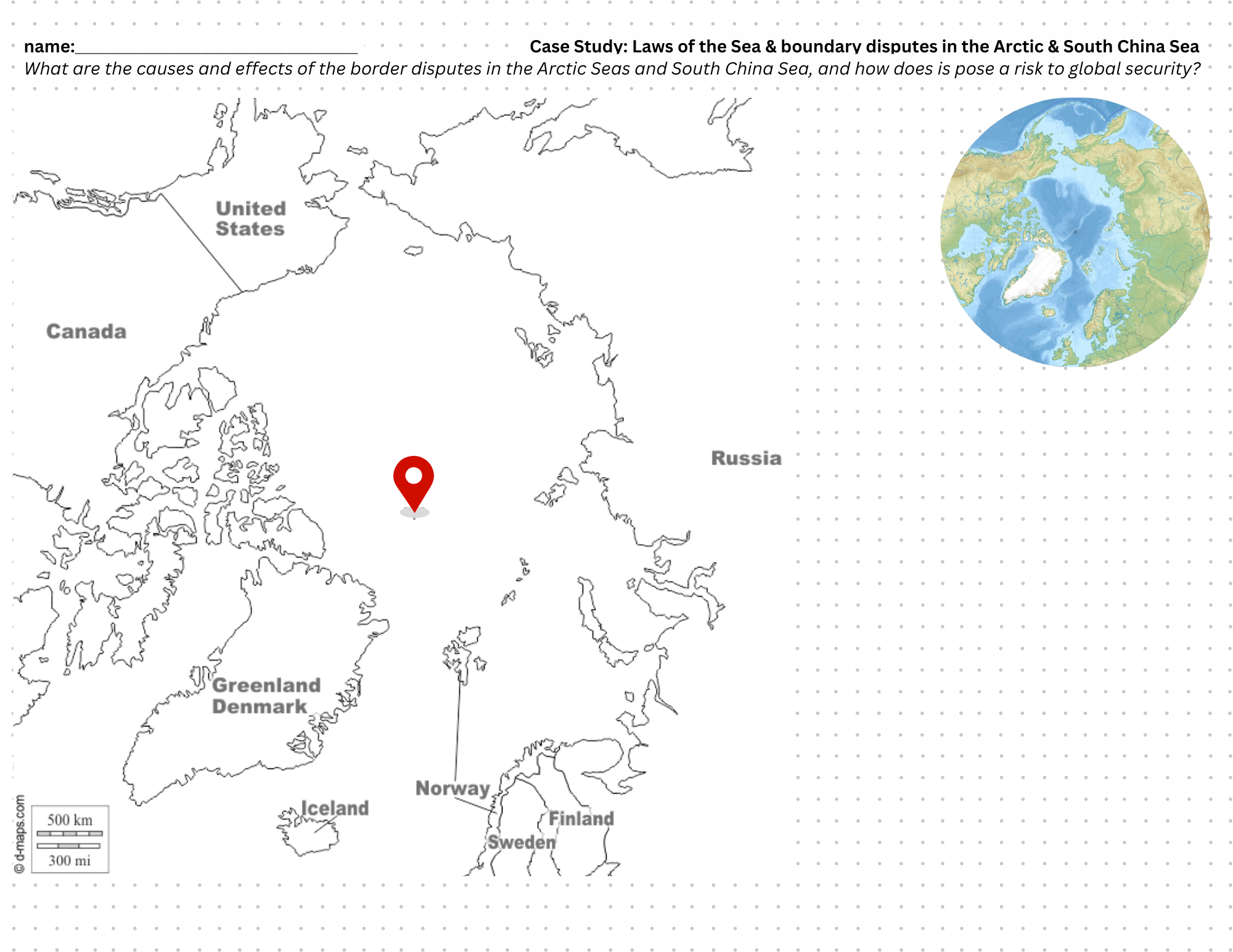
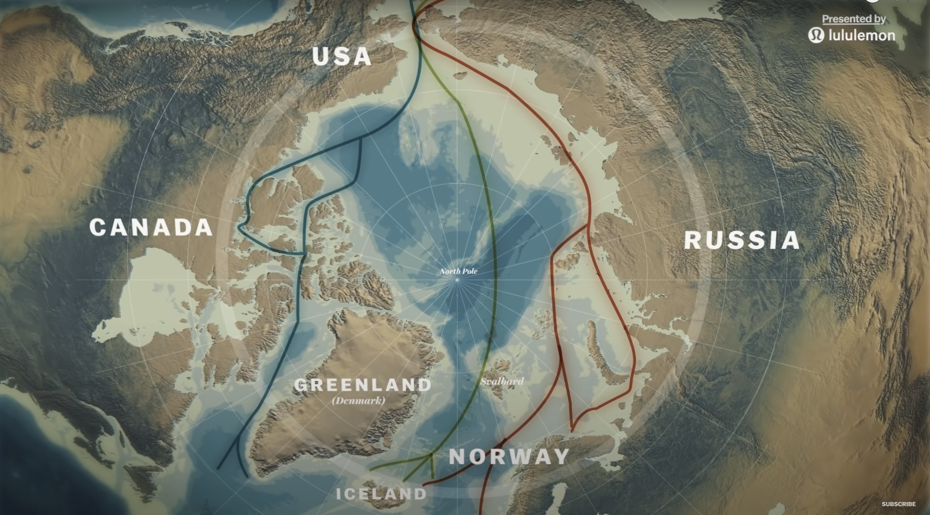
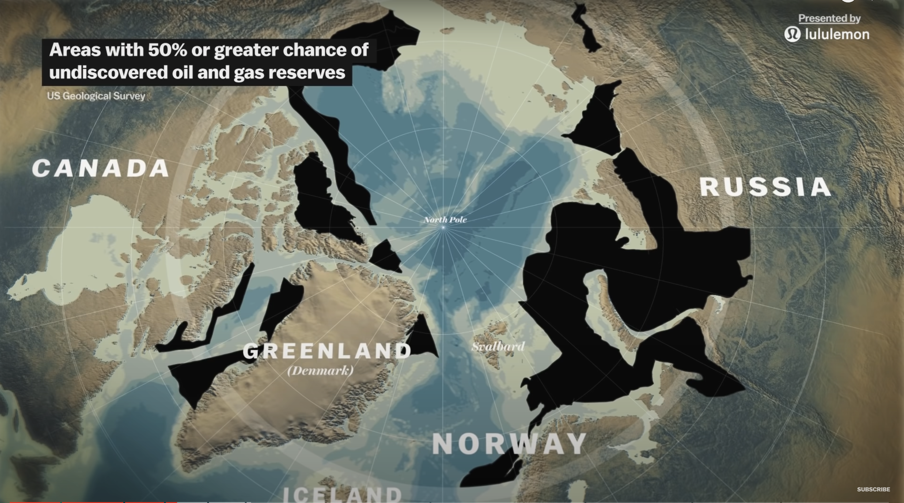
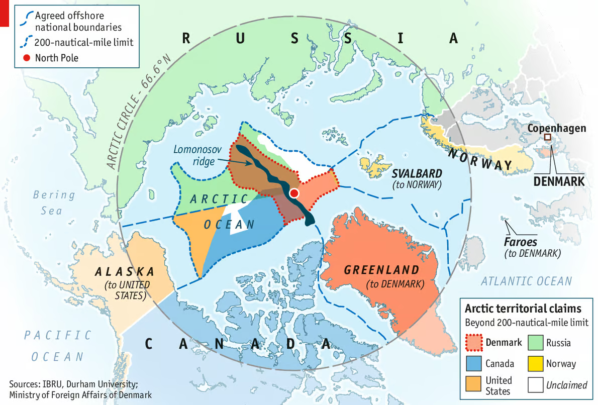
The Arctic Ocean is undergoing dramatic changes as rising temperatures melt away its sea ice. This has opened up new shipping routes, like the Northwest Passage, and revealed access to potential oil, natural gas, and mineral reserves buried beneath the ocean floor. Countries that border the Arctic—Russia, Canada, the United States, Norway, and Denmark (via Greenland)—are racing to claim new areas of the seafloor, especially parts of the extended continental shelf.
Under UNCLOS rules, a country can claim territory beyond its EEZ if it can prove that the underwater land is a natural extension of its continental shelf. This has led to a legal and scientific scramble as countries submit evidence to the UN while also deploying ships, submarines, and research missions to strengthen their claims. As the ice continues to melt, the Arctic is likely to see more competition and conflict over resources and sea control.
The South China Sea: Overlapping Claims and Artificial Islands
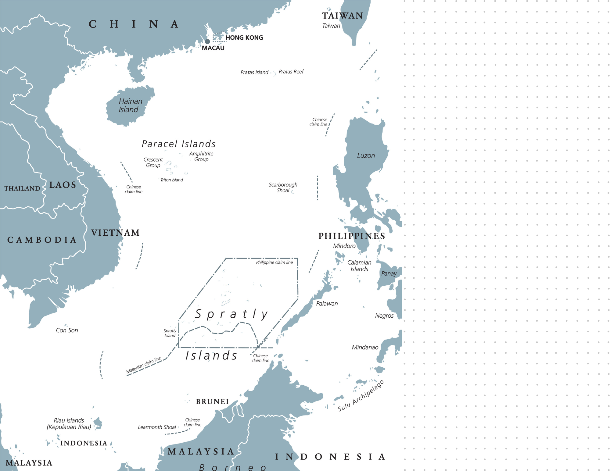
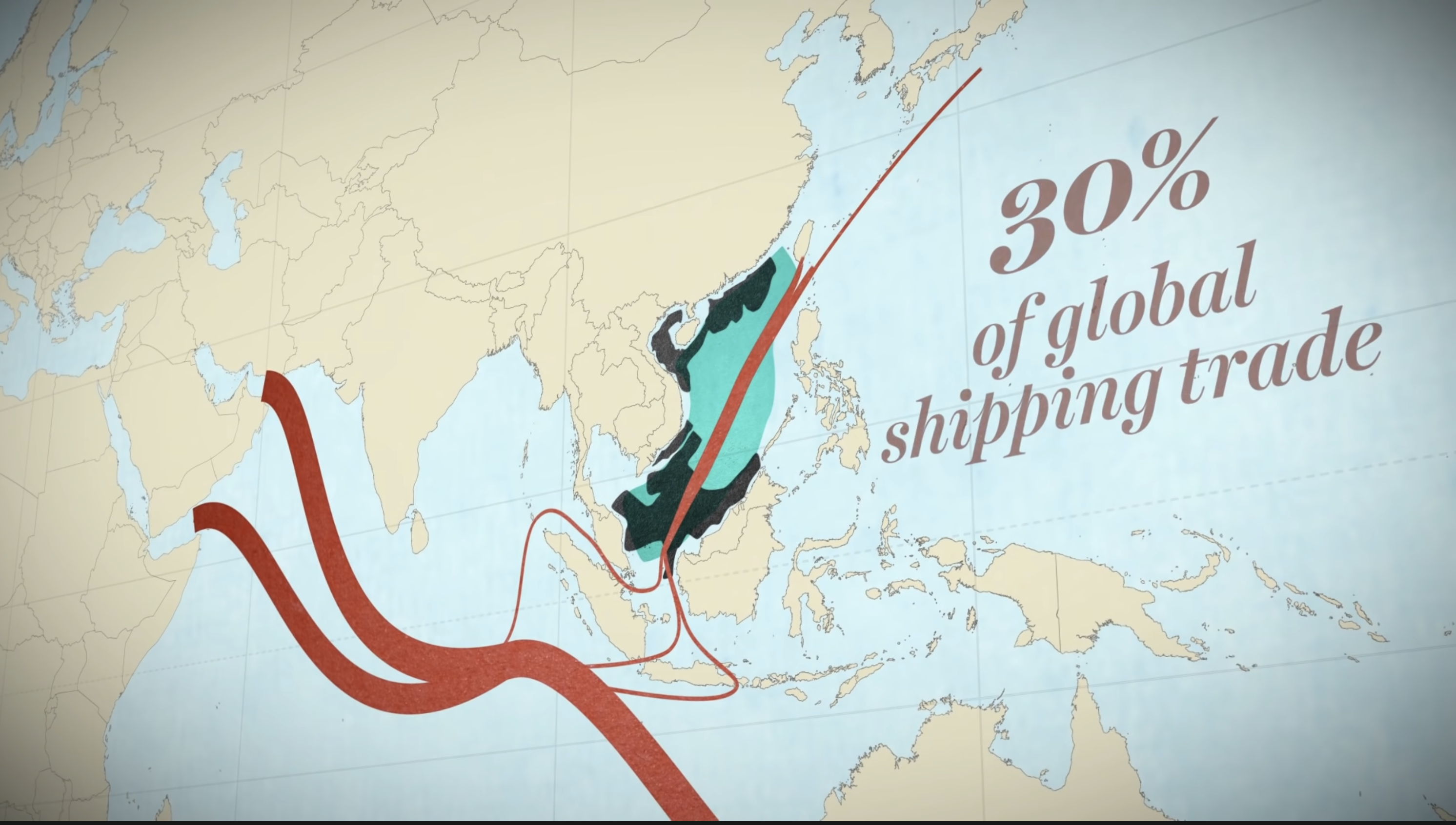
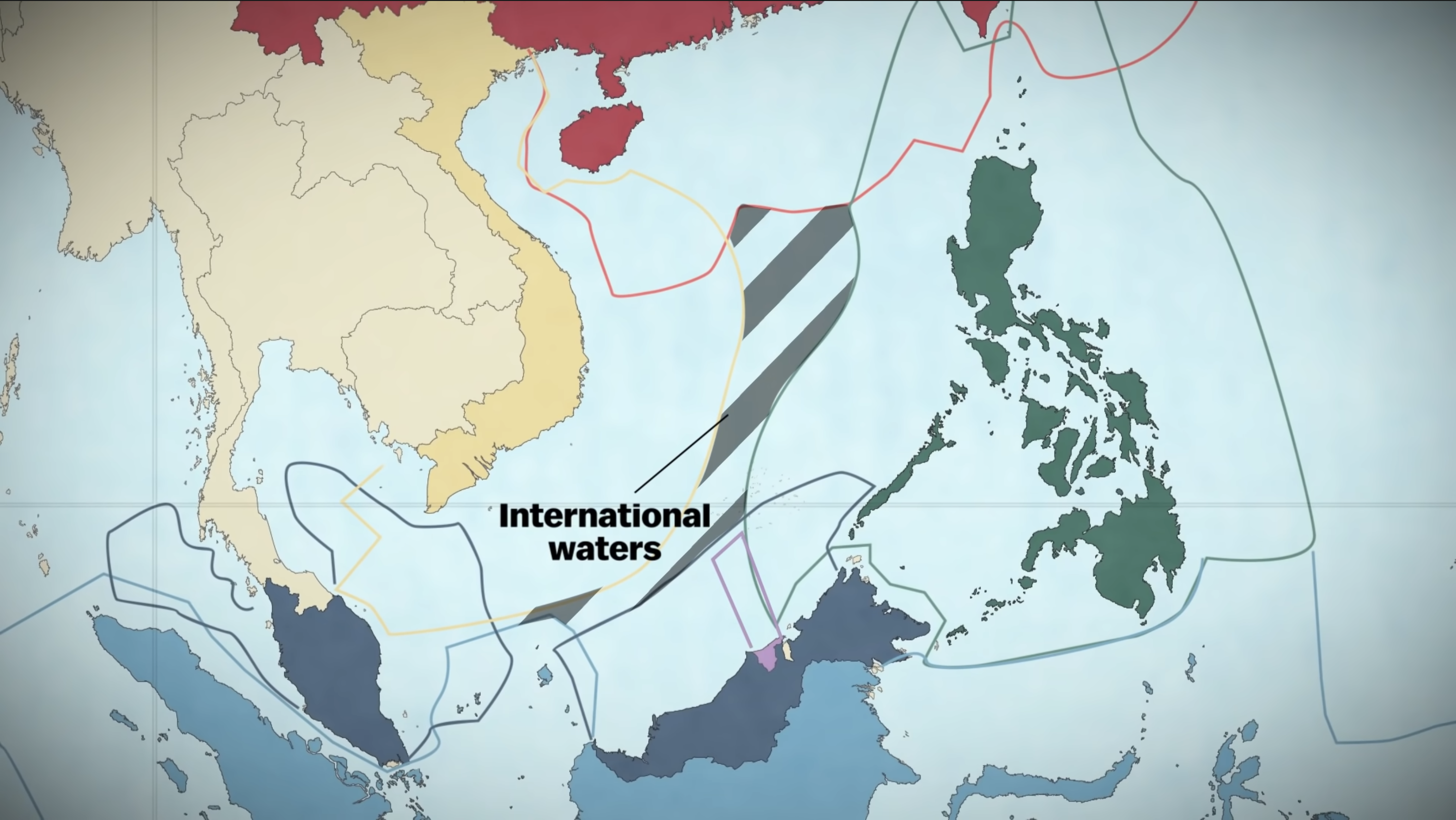
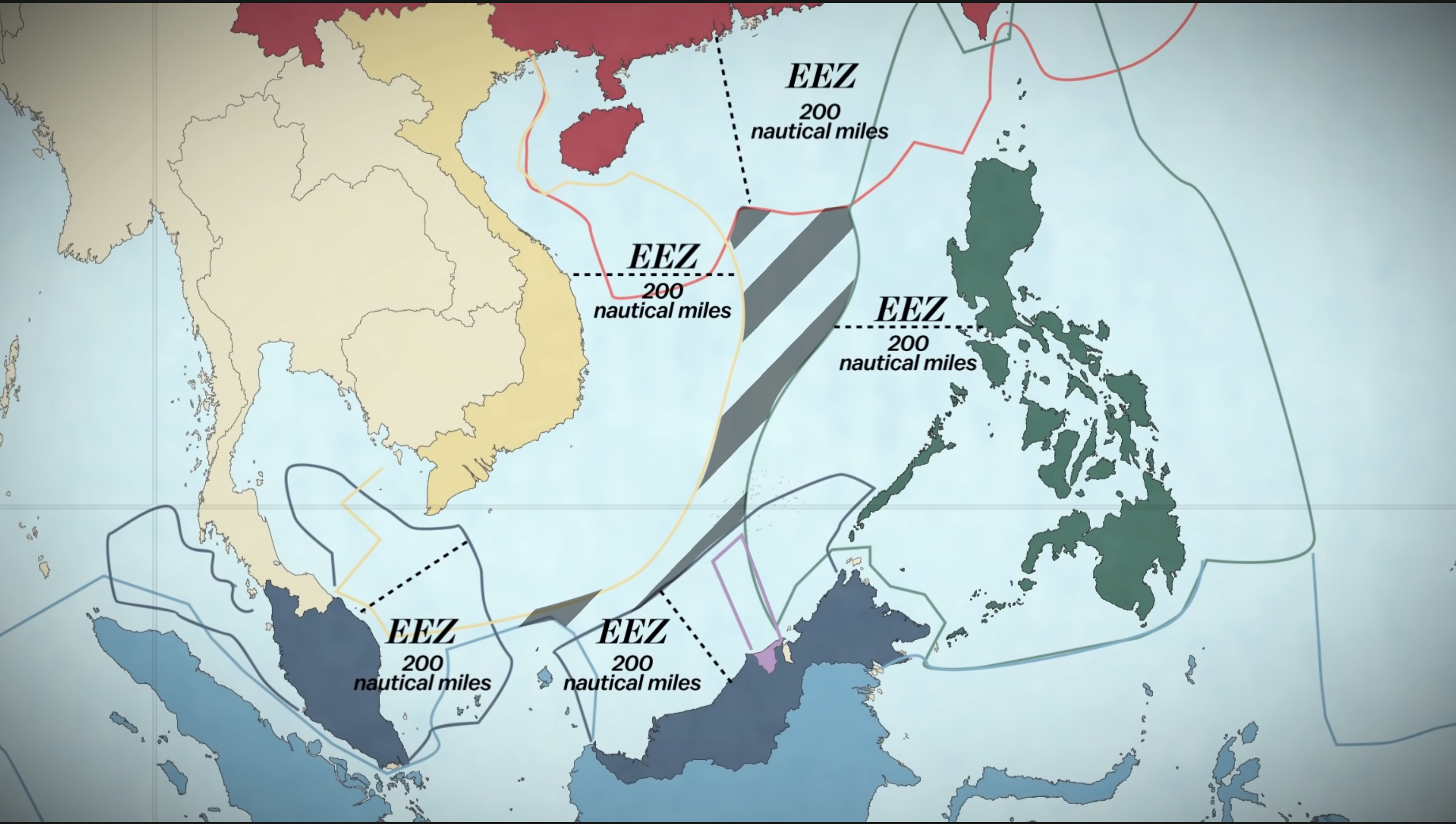
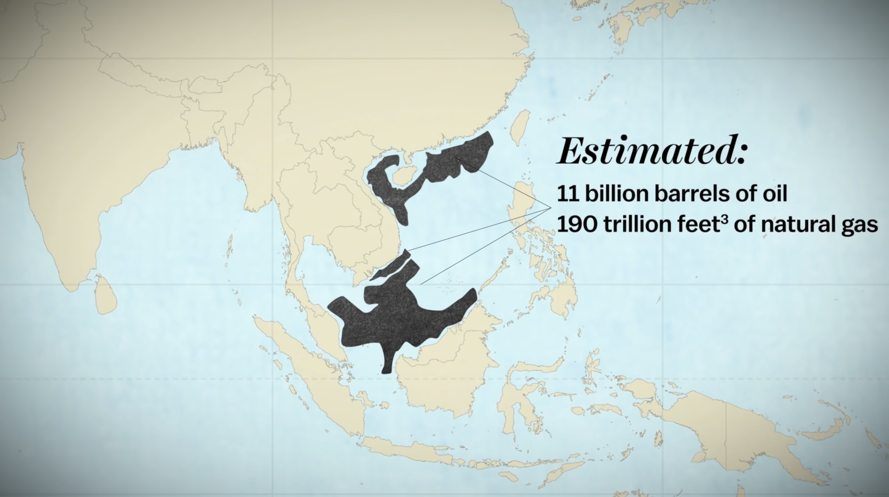
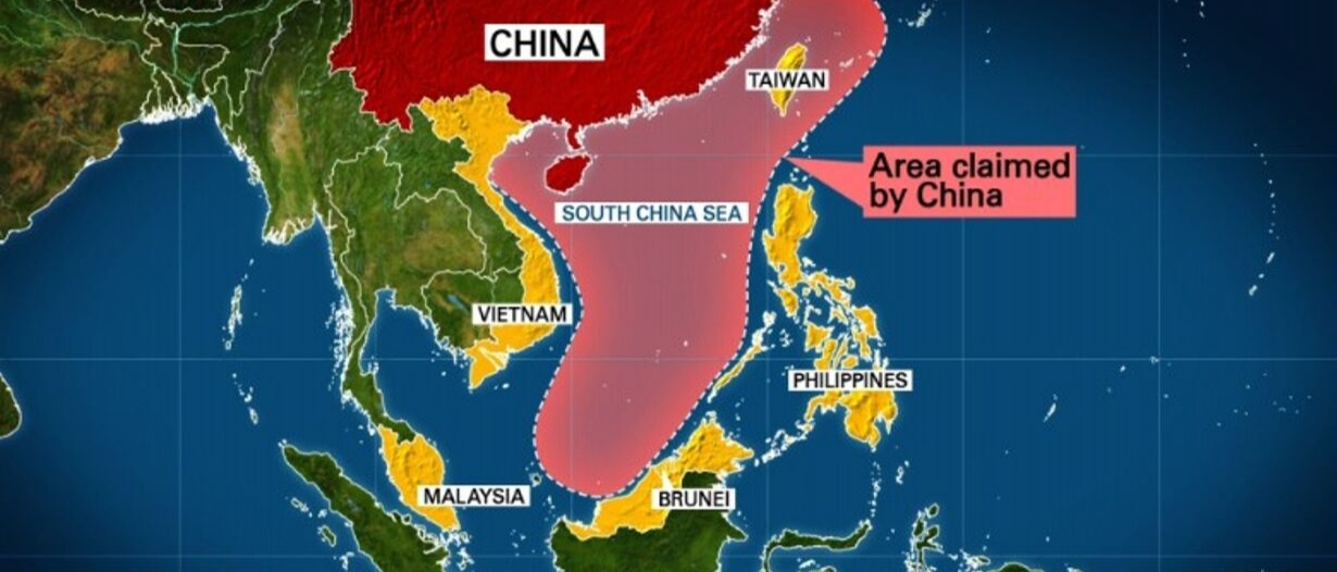
The South China Sea is one of the most disputed regions on Earth. It’s strategically important—a major global shipping lane, home to rich fishing waters, and believed to contain large energy reserves. Several countries—including China, Vietnam, the Philippines, Malaysia, Brunei, and Taiwan—have overlapping claims to parts of the sea, especially around features like the Spratly Islands and Paracel Islands.
The tension revolves around how each country interprets UNCLOS, especially when it comes to the 200-nautical-mile Exclusive Economic Zone (EEZ). China claims nearly the entire South China Sea through a loosely defined “Nine-Dash Line,” which stretches far beyond what UNCLOS would typically allow. To strengthen its claim, China has built artificial islands—complete with military airstrips and naval bases—on top of reefs in the Spratly Islands.
These actions have drawn global criticism, especially from countries like the Philippines, which took its case to an international tribunal in 2016. The court ruled in favor of the Philippines, saying China’s claims had no legal basis under UNCLOS. But China has rejected the ruling and continues to assert control over the area, leading to frequent standoffs with other nations’ navies and fishing fleets.
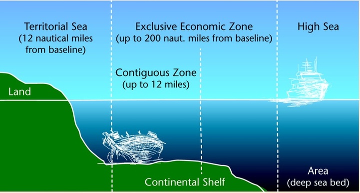
Territorial Waters: Full Control Up to 12 Miles Out
Under the United Nations Convention on the Law of the Sea (UNCLOS), every coastal country has the right to claim territorial waters—a zone that stretches up to 12 nautical miles (about 13.8 land miles) from its coast. Within this area, a country has full legal control, just like it does on land. That means it can enforce its own laws, control who enters, and decide how the waters are used.
But in places like the South China Sea, things get complicated. Countries like China, Vietnam, and the Philippines claim territorial waters around many small islands, reefs, and even tiny rocks. These features are often very close together, which means their 12-mile zones can overlap. When two countries claim the same land feature—or disagree about whether something is an island at all—they end up in conflict over whose territorial waters it really is.
These overlapping claims are at the heart of many disputes in the South China Sea, where control over even a small reef could mean ownership of important waters, trade routes, and underwater resources.
Contiguous Zone: A Buffer for Extra Control
Just past a country’s territorial waters is the contiguous zone, which extends up to 24 nautical miles from the coast. Countries don’t have full control here like they do in territorial waters, but they can still enforce important laws—especially those related to customs, immigration, and health. The purpose of this zone is to give countries a buffer area where they can stop illegal activities that might affect their territory.
In the South China Sea, countries like China use their claims over islands and reefs to try and stretch their contiguous zones farther out. But this creates tension. Other nations argue that some of the islands used to justify these claims are too small or even man-made, and shouldn’t be used to expand maritime zones under UNCLOS rules. These disagreements add to the larger regional conflict over who controls which parts of the sea.
Exclusive Economic Zone (EEZ): The Battle Over Resources
The Exclusive Economic Zone (EEZ) extends up to 200 nautical miles from a country’s coastline. Within this zone, the coastal state has special rights to explore, use, and manage natural resources—like fishing grounds, oil, natural gas, and minerals. While other countries can pass through or fly over this zone, only the coastal state has the right to profit from what’s in or under the water.
In the South China Sea, the EEZ rules are a central part of the ongoing dispute. This region is believed to contain vast reserves of oil and gas and supports some of the world’s richest fisheries. Countries like Vietnam, the Philippines, Malaysia, and Brunei all claim EEZs that stretch into the sea based on UNCLOS guidelines.
But China has claimed almost the entire South China Sea using a vague boundary known as the “Nine-Dash Line.” This line cuts deep into the EEZs of other nations, sparking conflict. In 2016, the Permanent Court of Arbitration ruled in favor of the Philippines, stating that China’s sweeping claims had no legal basis under international law. Despite this, China rejected the ruling and continues to expand its presence in the region—often by building artificial islands to try to support its claims.
The South China Sea shows how the EEZ—designed to give countries fair access to ocean resources—can become a flashpoint for conflict when claims overlap and powerful nations challenge the rules.
Territorial Disputes in the Arctic Ocean: Melting Ice, Rising Stakes
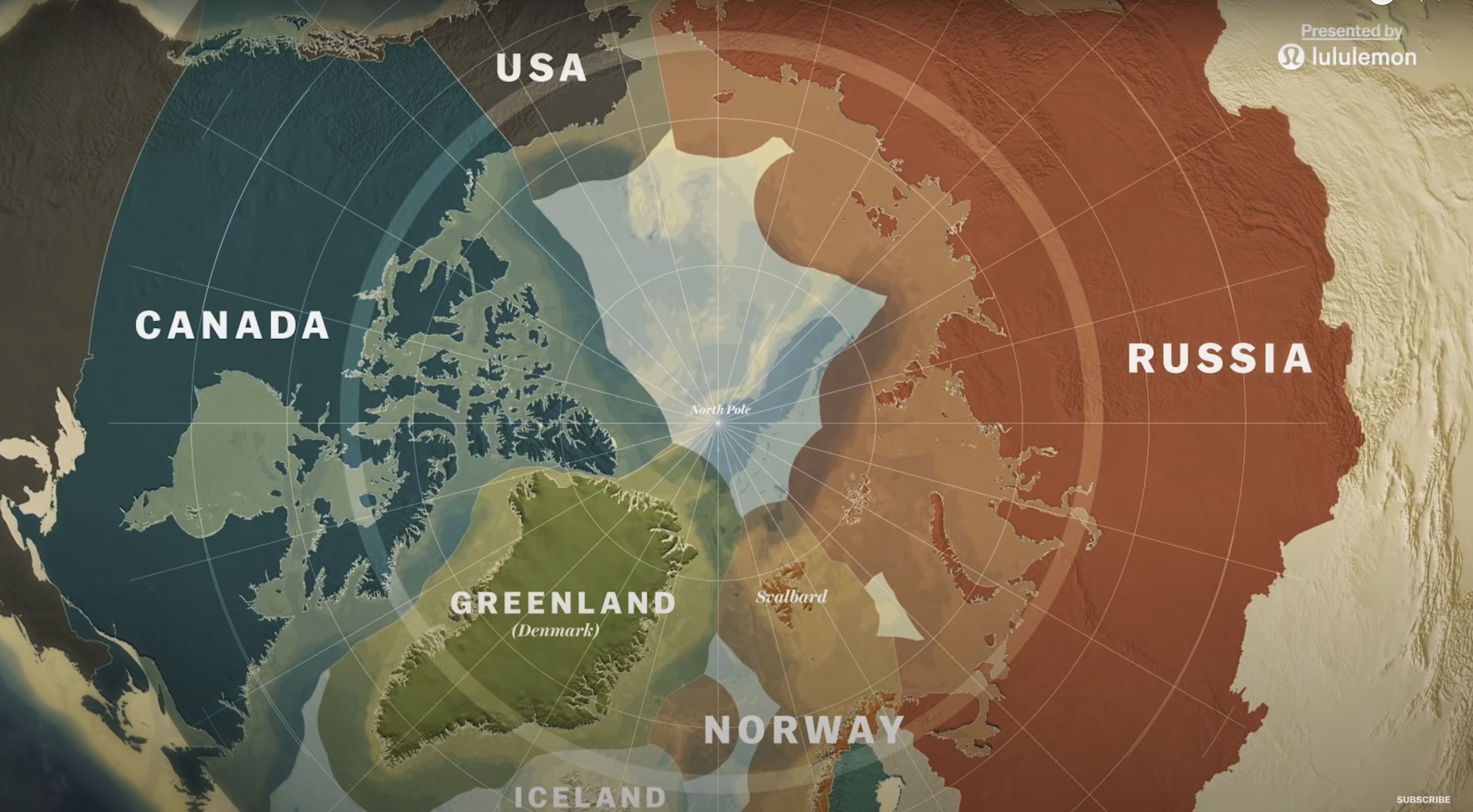
As climate change melts sea ice in the Arctic Ocean, it’s revealing more than just open water—it’s exposing huge opportunities for resources and trade, along with growing tensions over who controls what. Countries like Russia, Canada, the United States, Norway, and Denmark (via Greenland) are all trying to expand their claims in the region.
Territorial Waters and Contiguous Zones: Arctic Claims Close to Shore
Under UNCLOS, the five countries that border the Arctic Ocean—Russia, Canada, Norway, Denmark (via Greenland), and the United States—each have sovereignty over their territorial waters, which extend 12 nautical miles from their coastlines. Within this zone, they have full legal control, just like on land. They also control a contiguous zone up to 24 nautical miles, where they can enforce laws related to customs, immigration, and security.
While these zones are generally recognized and mapped, disputes still arise—not over the zones themselves, but over the classification of specific Arctic landforms like the Lomonosov Ridge and the Alpha-Mendeleev Ridge. If a country can prove that one of these underwater features is part of its natural continental shelf, it could greatly extend its maritime claims beyond the 200-mile EEZ, opening up access to valuable resources.
Exclusive Economic Zones (EEZs): Competing for Resources
Each Arctic nation is also entitled to an Exclusive Economic Zone (EEZ) that stretches 200 nautical miles from its baseline. Within its EEZ, a country has exclusive rights to fish, drill, and extract resources from the sea and seafloor. But in a region with closely spaced coastlines and overlapping claims, EEZ boundaries are often disputed.
Some notable disputes include:
- Russia and Norway: In 2010, the two countries signed a treaty to resolve overlapping claims in the Barents Sea, though competition over fishing rights and oil and gas deposits near their shared boundary continues.
- Canada and the United States: Both countries claim part of the Beaufort Sea, where large oil and gas reserves are believed to exist. The disagreement centers on how the boundary should be drawn from the Alaska–Yukon border.
- Denmark (Greenland) and Canada: The two countries have long disputed areas like the Lincoln Sea and the tiny, uninhabited Hans Island, though they recently agreed to split Hans Island, creating the world’s smallest land border.
Extended Continental Shelf: Going Beyond 200 Miles
The biggest Arctic disputes come from attempts to claim the extended continental shelf—undersea land beyond the 200-mile EEZ. Under UNCLOS, if a country can prove through scientific data that this underwater area is a natural extension of its landmass, it can request rights to the resources on and under the seabed.
- Russia: Russia has been especially aggressive in this process, submitting evidence to the Commission on the Limits of the Continental Shelf (CLCS) to claim large areas, including the North Pole and the Lomonosov Ridge. These claims overlap with those of Canada and Denmark, creating a major unresolved dispute.
- Canada and Denmark: Both countries argue that the Lomonosov Ridge is geologically connected to their land and have filed overlapping claims to parts of the Arctic seabed, including the area beneath the North Pole.
- United States: The U.S. has not signed UNCLOS, so it cannot formally submit claims to the CLCS. However, it continues to assert control over its Arctic waters through national laws and has maintained a strong military presence in the region.
International Waters and Strategic Competition: The Arctic’s High Stakes
Beyond EEZs and extended shelf claims lies the high seas—international waters where no one has control. However, in the Arctic, high seas are shrinking due to overlapping claims. Some regions thought to be international waters are now being claimed by multiple nations. This is raising tensions despite efforts at cooperation, like those through the Arctic Council and the Ilulissat Declaration.
- Shipping Routes: As the Arctic ice melts, new paths like the Northern Sea Route (along Russia’s coast) and the Northwest Passage (through Canada’s Arctic islands) are opening. Both routes could dramatically reduce shipping times between Europe and Asia. Russia and Canada claim these passages as internal waters, but other countries, including the U.S., argue they should be international straits, open to all.
- Military Posturing: Russia has expanded its military footprint in the Arctic, reopening Soviet-era bases, building new ones, and deploying nuclear-powered icebreakers. In response, NATO allies have increased Arctic training missions and surveillance to assert their own interests in the region.
The Future of Arctic Disputes: Frozen Conflicts in a Thawing World
As the Arctic becomes more accessible, the stakes are only getting higher. Control over energy reserves, trade routes, and sea territory is fueling a new era of competition and negotiation. Settling these disputes will require careful diplomacy, adherence to international law, and a balance between economic development and environmental protection.
The Arctic is no longer an isolated frontier—it’s a critical arena for 21st-century geopolitics, where climate, law, and global power all collide.