Types of Urban Spaces
megacity
metacity
global city
boomburb
exurb
edge city
informal settlements
Urban Concepts
counter-urbanization
urban sprawl
urban decentralization
Urban Trends
core vs. developing countries today & the future
impact of technology
demographic transition

The process of urbanization and suburbanization appears differently on the cultural landscape in different regions of the world. In North America after World War II, changes in transportation, demographics, and the economy dramatically changed how cities developed. In the periphery and semi-periphery, rapid population growth of cities has affected how geographers classify and study the urban areas of the world.
Suburbanization
A suburb is a largely residential area adjacent to an urban area. Suburbanization involves the process of people moving, usually from cities, to residential areas on the outskirts of cities. There, they form communities that are connected to the city for jobs and services. However, suburbs are often less-densely populated and less-ethnically diverse than inner cities.
Causes of Suburbanization
Several causes contributed to the growing suburbanization in North America after World War II. Among these were economic expansion, greater purchasing power for many families, the growth of a car-centered lifestyle, and the government’s construction of a vast system of new highways that allowed workers to commute from their city jobs to suburban homes. In the United States, the Federal Housing Administration provided mortgage loans for families to move to the suburbs, which were newly zoned for single-family housing.
Racial tensions provided another impetus for suburban growth. As African Americans came to the North in search of jobs and better education during and after World War II, many White Americans moved to the suburbs in what became known as “White flight.” Continued government investment in suburban growth, along with a lack of investment in inner cities, hastened both urban decline and suburban growth. Industries and jobs left the cities, and residents followed. In addition, highways were sometimes built in locations that uprooted or divided existing urban communities.
Shifting Trends
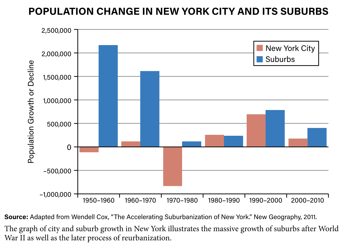
The process of suburbanization is one effect of urban growth. In the developed world, especially North America, it has been the most prominent change in urban areas since World War II.
Urban areas since the middle of the 20th century. In 1960, the U.S. population was roughly equally divided with about 60 million people living in each of the three types of areas—urban, suburban, and rural. According to the Pew Institute, in 2016, 55 percent (175 million) of Americans lived in suburban counties, 31 percent (98 million) in urban, and 14 percent (46 million) in rural counties. Suburbs are now the dominant form of residential living in the United States.
As economic and residential activities continue to decentralize into the suburbs, cities spread out horizontally, creating a sprawling landscape. Sprawl is the rapid expansion of the spatial extent of a city and occurs for numerous reasons:
- growth of suburbs
- lower land costs in suburbs compared to inner cities
- lower density single family housing
- weak planning laws
- the continuing growth of car culture
In the United States, sprawl is most common in fast-growing areas in the Southeast and West. A specific process that encourages sprawl is leap-frog development, where developers purchase land and build communities beyond the periphery of the city’s built area. As a result of sprawl, the urban footprint of American cities, such as Atlanta, grew larger than those of more populated cities in other regions of the world. Atlanta now covers over 8,300 square miles and contains 6 million people. In contrast, cities in other parts of the world are much smaller in physical size. For example, Mexico City is 580 square miles but contains over 21 million people, resulting in a much more compact and densely populated city.
New Forms of Land Use
As a result of the suburbanization process, new land-use forms have been created. Boomburbs, or boom burbs, are rapidly growing communities (over 10 percent per 10 years), have a total population of over 100,000 people, and are not the largest city in the metro area. This type of community develops differently than a traditional city and usually do not have a dense urban center. Examples include Mesa, Arizona; Plano, Texas; and Riverside, California.
Another new land use is found near key locations along transportation routes that has mini downtowns of hotels, malls, restaurants, and office complexes. Modern geographers have dubbed these edge cities, which are nodes of economic activity that have developed in the periphery of large cities. They usually have tall office buildings, a concentration of retail shops, relatively few residences, and are located at the junction of major transportation routes.
While cities are the destination for many of the world’s migrants, the counter-flow of urban residents leaving cities is known as counter-urbanization or deurbanization. Many of these migrants are relocating to exurbs, the prosperous residential districts beyond the suburbs. Contributing to exurbanism is the ability of people to work remotely via technology, which
removes the need to commute. Other factors include relative affordability of land in these areas and cultural preferences. These exurbs tend to have expansive lots and large single-family homes. People who live in these areas want tranquility and privacy while still having connections to an urban center.
Suburbanization has affected rural areas by increasing population density, building homes and businesses on former farmlands, and adding new residents from urban backgrounds to communities. However, suburbanization itself is currently changing in North America, as some suburbanites return to live in the city, in a process called reurbanization.

Megacities and Metacities
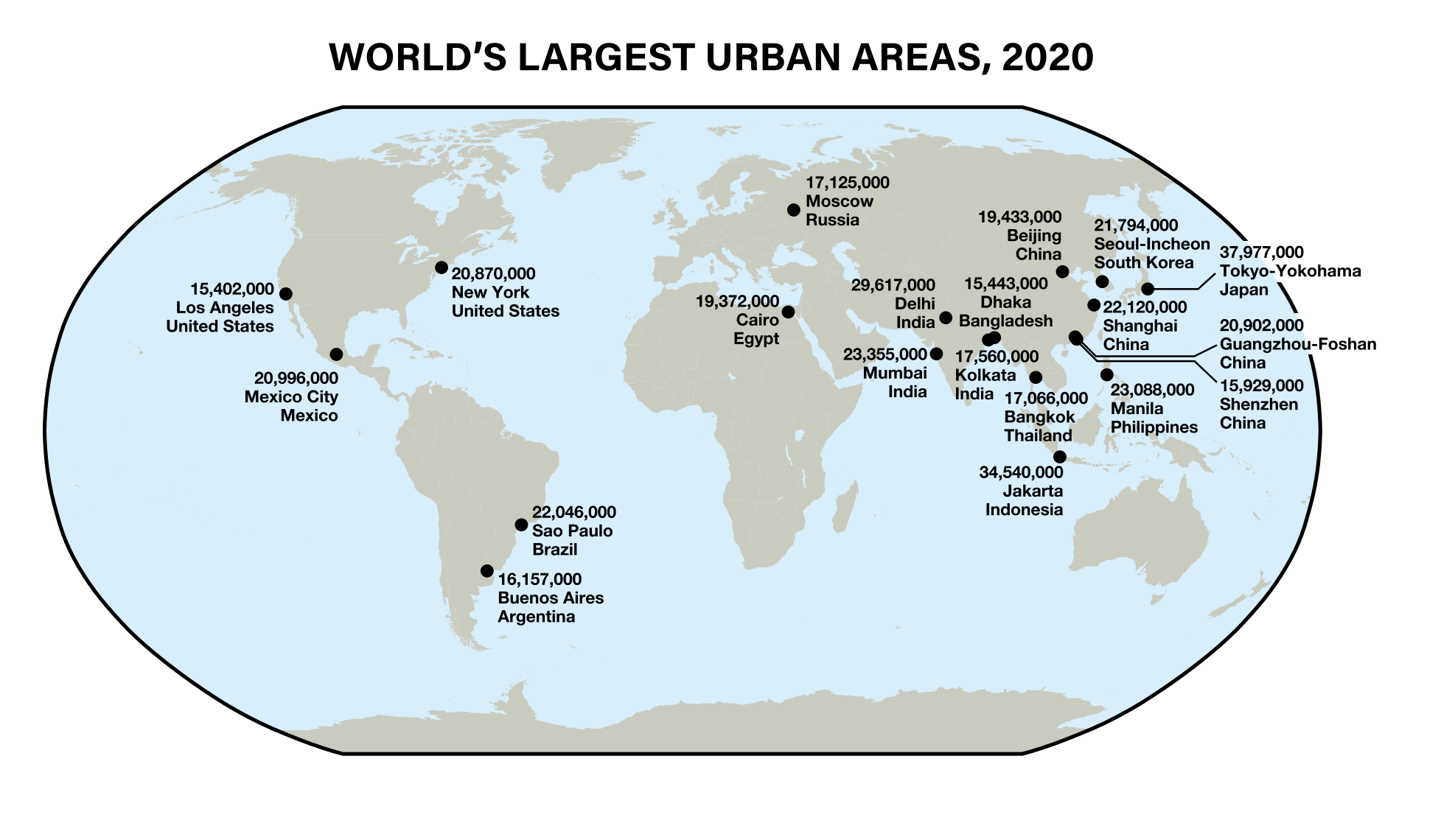
Megacities and metacities are the world’s largest cities. Megacities have a population of more than 10 million people. Because of the rapid growth of cities in the 21st century a new type of city has emerged—the metacity. Metacities, sometimes called hypercities, are defined in two ways:
- continuous urban area with a population greater than 20 million people
- attributes of a network of urban areas that have grown together to form a larger interconnected urban system
Megalopolis
The term megalopolis goes back to the early 1900s and describes a chain of connected cities. It became more common after 1961, when French geographer Jean Gottmann used it to describe the continuously developed string of cities from Boston—through New York City, Philadelphia, and Baltimore—to Washington, DC. The “Bos-Wash Corridor” now includes nearly 50 million residents.
These cities had grown until they essentially merged into a single conurbation, an uninterrupted urban area made of towns, suburbs, and cities. The cities crossed state boundaries and exceeded the definition of a metropolitan area, which is focused on a single, urban center. Gottmann noted that, although legally the major cities remained separate, they and their suburbs had become a single region that had taken on some characteristics of a single, massive city.
Since that time, with urban growth increasing across the planet, other cities have combined into megalopolises. The corridor in California from San Diego through Los Angeles to San Francisco is a single, growing metropolitan corridor on the West Coast of the United States. Tokyo through Yokohama is a megalopolis in Japan.
Urbanization in the Developing World
Megacities were once found at only the centers of large empires or the most powerful countries. However, that pattern has changed. In the past century, megacities have become more common in less-developed countries because of high birth rates and increased rural-to-urban migration. Of the 20 largest urban areas in the world in 2020, 15 were in semiperiphery or periphery countries.
These urban giants can spread across political borders and exert an influence that is felt regionally, and even worldwide. This influence is due to the size of their populations, but in other cases, their influence is derived from the city’s political, economic, and cultural power. The world’s first and largest metacity is Tokyo, Japan, with a current population of over 37 million. New York City is the tenth largest with just over 20 million people. An emerging metacity near Shenzhen, China, is predicted to exceed 120 million people by 2050.

Megacities in relatively poor countries face the same challenges as megacities in wealthy countries, but without as many resources to respond. Social problems between ethnic groups, joblessness, lack of infrastructure, inadequate housing, and environmental problems—such as Mexico City’s severe air pollution—are common in all megacities.
World Cities
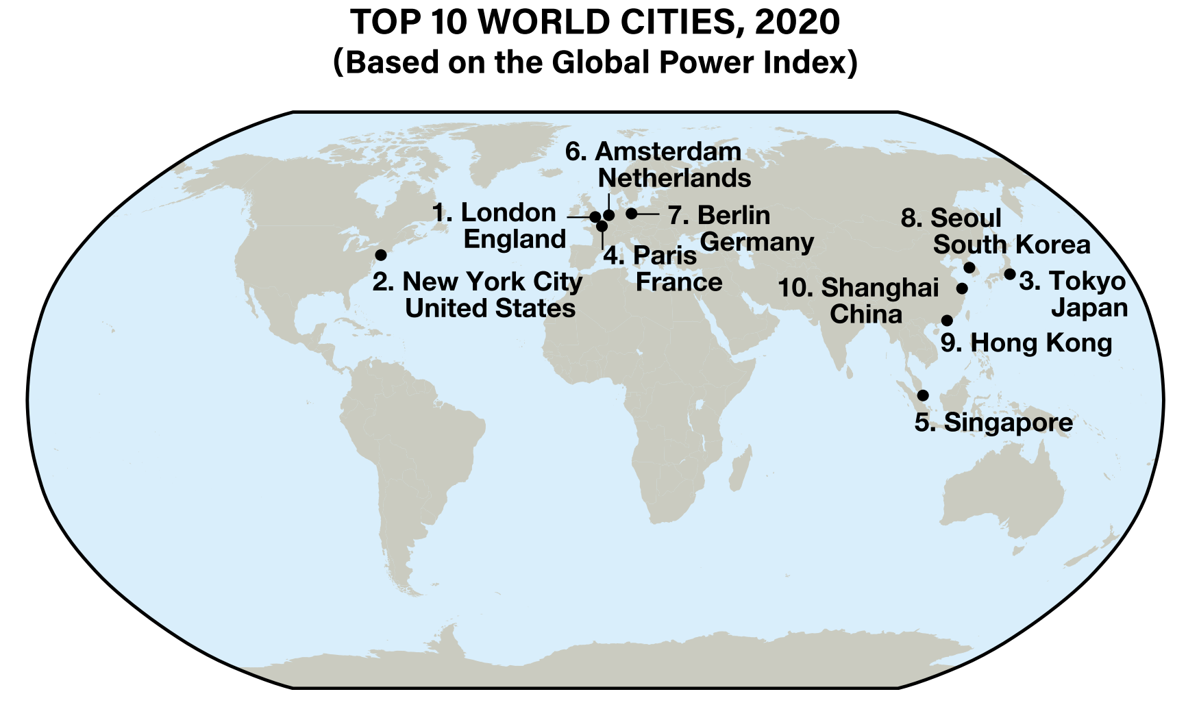
The world’s largest cities are not always the most influential. Cities such as New York, London, Tokyo, and Paris are world cities, or global cities, that exert influence far beyond their national boundaries. All are currently media hubs and financial centers with influential stock exchanges, banks, and corporate headquarters. Many are the headquarters of international organizations. For example, New York is home to the United Nations. World cities are the control centers for the global economy where key decisions about products, manufacturing, banking, cultural trends, marketing, and information originate.
Researchers rank a city’s influence based on its financial power, innovation, academic resources, cultural influence, livability, connectivity, accessibility, and political influence. The top 10 world cities in 2020 according to the Global Power City Index are shown in the map below.

The decisions made by leaders in world cities impact all people, even those in rural areas or small towns. World cities are the most powerful of all urban centers and drive globalization. These influential cities are very interconnected via transportation and communication networks. Leaders of world cities typically wield political power on a national and international scale that rivals the power of leaders of entire countries.
Connectivity and Urban Hierarchy
Cities at all scales of geography do not function in isolation, rather they are a part of a larger urban system. Systems of cities have an urban hierarchy, or ranking, based on influence or population size. For a city to be influential, it must have connectivity, or be connected to regional, national, and global networks. World cities operate on a global scale but also have connectivity to smaller cities within a country’s urban system.
Nodal cities are command centers on a regional and occasionally national level. Cities like Denver, Phoenix, or Minneapolis are not as influential as world cities but possess significant power within a region of the country. These cities will have some corporate headquarters and numerous regional offices for transnational companies, while they also serve as major entertainment, cultural, and economic centers within their regions. In order to maintain global connectivity, these cities have developed road systems, large airports, and advanced communication networks that connect to smaller cities in their regions and to world cities, such as New York, Chicago, or Los Angeles.
Cities specializing in certain functions are another level of the urban hierarchy. Examples include Austin, Texas (government); Las Vegas, Nevada (entertainment); Elkhart, Indiana (manufacturing); and Norfolk, Virginia (military).
